By Matt Williams via Universe Today, 24 June 2015
For people living in oceanfront communities, the prospect of a tsunami is a frightening one. Much like earthquakes, volcanoes, hurricanes and tornadoes, tsunamis are one of the most destructive natural forces on the planet. And much like these other phenomena, they require the right conditions to happen and are more common in some areas of the world than others.
Knowing how and when a tsunami will strike has therefore a subject of great interest for scientists over the ages. But for anyone who has lived in certain parts of the world where “tsunami zones” are common – namely Japan and the South Pacific – it is a matter of survival.
Definition:
Numerous terms are used in the English language to describe large waves created by the displacement of water, with varying degrees of accuracy. The term tsunami, for example, is literally translated from Japanese to mean “harbor wave”. There are only a few other languages that have an equivalent native word, though similar meanings can be found in Indonesia, Sri Lanka, and the Indian Subcontinent.
The term tidal wave has also been used, which is derived from the most common appearance of a tsunami – an extraordinarily high tidal bore. However, in recent years, the term “tidal wave” has fallen out of favor with the scientific community because tsunami actually have nothing to do with tides, which are produced by the gravitational pull of the moon and sun rather than the displacement of water.
After the tsunami of 365 CE devastated Alexandria, Roman historian Ammianus Marcellinus described the typical sequence of a tsunami. His descriptions included an earthquake and the sudden retreat of the sea, followed by a gigantic wave.
More modern examples include the 1755 Lisbon earthquake and tsunami (which was caused by activity in the Azores–Gibraltar Transform Fault); the 1783 Calabrian earthquakes, which caused several ten thousand deaths; and the 1908 Messina earthquake and tsunami – which caused 123,000 deaths in Sicily and Calabria and is considered one of the most deadly natural disasters in modern European history.
But by far, the 2004 Indian Ocean earthquake and tsunami was the most devastating of its kind in modern times, killing around 230,000 people and laying waste to communities throughout Indonesia, Thailand, and Southern Asia.
In 2010, an earthquake triggered a tsunami which devastated several coastal towns in south-central Chilem, damaged the port at Talcahuano and caused 4334 confirmed fatalities. The earthquake also generated a blackout that affected 93 percent of the Chilean population.
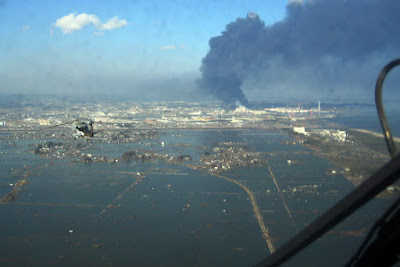
In 2011, an earthquake off the Pacific coast of Tohoku led to a tsunami that struck Japan and led to 5,891 deaths, 6,152 injuries, and 2,584 people to be declared missing across twenty prefectures. The tsunami also caused meltdowns at three reactors in the Fukushima Daiichi Nuclear Power Plant complex.
Tsunamis are a force of nature, without a doubt. And knowing when, where, and how severely they will strike is intrinsic to ensuring that we can limit the damage they do cause.
Universe Today has articles on about tsunamis and causes of tsunamis.
For more information, try tsunami and causes of tsunamis.
Astronomy Cast has an episode on Earth.
Source:
Wikipedia
Posted with permission from UT

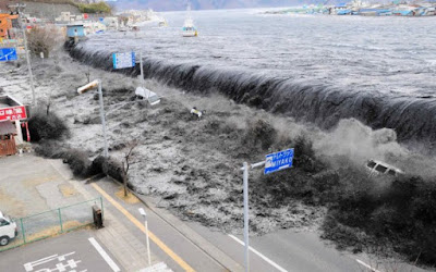
The wave from a tsunami crashes over a street in Miyako City, Japan on March 11th, 2011. Credit: REUTERS/Mainichi Shimbun
For people living in oceanfront communities, the prospect of a tsunami is a frightening one. Much like earthquakes, volcanoes, hurricanes and tornadoes, tsunamis are one of the most destructive natural forces on the planet. And much like these other phenomena, they require the right conditions to happen and are more common in some areas of the world than others.
Knowing how and when a tsunami will strike has therefore a subject of great interest for scientists over the ages. But for anyone who has lived in certain parts of the world where “tsunami zones” are common – namely Japan and the South Pacific – it is a matter of survival.
Definition:
Numerous terms are used in the English language to describe large waves created by the displacement of water, with varying degrees of accuracy. The term tsunami, for example, is literally translated from Japanese to mean “harbor wave”. There are only a few other languages that have an equivalent native word, though similar meanings can be found in Indonesia, Sri Lanka, and the Indian Subcontinent.
The term tidal wave has also been used, which is derived from the most common appearance of a tsunami – an extraordinarily high tidal bore. However, in recent years, the term “tidal wave” has fallen out of favor with the scientific community because tsunami actually have nothing to do with tides, which are produced by the gravitational pull of the moon and sun rather than the displacement of water.

Tsunamis initiate when an earthquake causes the seabed to rupture, which leads to a rapid decrease in sea surface height directly above it. Credit: howitworksdaily.com
The term seismic sea wave also is used to refer to the phenomenon, due to the fact that the waves most often are generated by seismic activity such as earthquakes. However, like “tsunami,” “seismic sea wave” is not a completely accurate term, as forces other than earthquakes – including underwater landslides, volcanic eruptions, underwater explosions, land or ice slumping into the ocean, meteorite impacts, or even sudden changes in weather – can generate such waves by displacing water.
Causes:
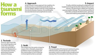
The principal cause of a tsunami is the displacement of a substantial volume of water or perturbation of the sea. This is usually the result of earthquakes, landslides, volcanic eruptions, glacier calvings, or more rarely by meteorites and nuclear tests. The waves formed in this way are then sustained by gravity.
Tectonic earthquakes trigger tsunamis when the sea floor abruptly deforms and vertically displaces the water above. More specifically, a tsunami can be generated when thrust faults associated with convergent or destructive plate boundaries move abruptly and displace water.
Tsunamis have a small amplitude (wave height) offshore, and a very long wavelength (often hundreds of kilometers long), and only grow in height when they reach shallower water. Once there, the wavelength shortens as the wave encounters resistance, thus increasing the amplitude increases and causing the wave to rears up in a massive tidal bore.
In the 1950s, it was discovered that tsunamis larger than what had previously been believed possible could be caused by giant submarine landslides. These rapidly displace large water volumes, as energy transfers to the water at a rate faster than the water can absorb. Their existence was confirmed in 1958, when a giant landslide in Lituya Bay, Alaska, caused the highest wave ever recorded (524 meters/1700 feet).


Causes:
The principal cause of a tsunami is the displacement of a substantial volume of water or perturbation of the sea. This is usually the result of earthquakes, landslides, volcanic eruptions, glacier calvings, or more rarely by meteorites and nuclear tests. The waves formed in this way are then sustained by gravity.
Tectonic earthquakes trigger tsunamis when the sea floor abruptly deforms and vertically displaces the water above. More specifically, a tsunami can be generated when thrust faults associated with convergent or destructive plate boundaries move abruptly and displace water.
Tsunamis have a small amplitude (wave height) offshore, and a very long wavelength (often hundreds of kilometers long), and only grow in height when they reach shallower water. Once there, the wavelength shortens as the wave encounters resistance, thus increasing the amplitude increases and causing the wave to rears up in a massive tidal bore.
In the 1950s, it was discovered that tsunamis larger than what had previously been believed possible could be caused by giant submarine landslides. These rapidly displace large water volumes, as energy transfers to the water at a rate faster than the water can absorb. Their existence was confirmed in 1958, when a giant landslide in Lituya Bay, Alaska, caused the highest wave ever recorded (524 meters/1700 feet).

A village near the coast of Sumatra that was devastated by the Tsunami that struck South-East Asia in 2004. Credit: US Navy/Public Domain
In general, landslides generate displacements mainly in the shallower parts of the coastline, such as in closed bays and lakes. But an open oceanic landslide large enough to cause a tsunami across an ocean has not yet happened since the advent of modern seismology, and only rarely in human history.
Meteorological phenomena, such tropical cyclones, can generate a storm surge that will cause sea levels to rise, often in coastal regions. These are what is known as meteotsunamis, which are tsunamis triggered by sudden changes in weather. When such tsunamis reach shore, they rear up in shallows and surge laterally, just like earthquake-generated tsunamis.
Tsunamis can also be triggered by external factors, such as meteors or human intervention. For instance, when a meteor of significant strikes a region of the ocean, the resulting impact is enough to displace high volumes of water, thus triggering a tsunami. There has also been much speculation since World War II of how a nuclear detonations have trigger a tsunami, but all attempts at research (especially in the Pacific) have yielded poor results.
Characteristics and Effects:
Tsunamis can travel at well over 800 kilometers per hour (500 mph), but as they approach the coast, wave shoaling compresses the wave and its speed decreases to below 80 kilometers per hour (50 mph). A tsunami in the deep ocean has a much larger wavelength of up to 200 kilometers (120 mi), but diminishes to less than 20 kilometers (12 mi) when it reaches shallow water.
When the tsunami’s wave peak reaches the shore, the resulting temporary rise in sea level is termed run up. Run up is measured in metres above a reference sea level. A large tsunami may feature multiple waves arriving over a period of hours, with significant time between the wave crests.
Tsunamis cause damage by two mechanisms. First, there is the smashing force of a wall of water traveling at high speed, while the second is the destructive power of a large volume of water draining off the land and carrying a large amount of debris with it.
It is often difficult for people to recognize a tsunami in the open ocean because the waves are much smaller further out at sea than they are close to shore. As with earthquakes, several attempts have been made to set up scales of tsunami intensity or magnitude to allow comparison between different events.
Ships try to extinguish a blaze at oil refinery tanks in Ichihara, Chiba Prefecture, after the tsunami that struck in March, 2011. Credit: EPA
The first scales used routinely to measure the intensity of tsunami were the Sieberg-Ambraseys scale, used in the Mediterranean Sea and the Imamura-Iida intensity scale, used in the Pacific Ocean. This latter scale was modified by Soloviev to become the Soloviev-Imamura tsunami intensity scale, which is used in the global tsunami catalogs compiled by the NGDC/NOAA and the Novosibirsk Tsunami Laboratory as the main parameter for the size of the tsunami.
In 2013, following the intensively studied tsunamis in 2004 and 2011, a new 12 point scale was proposed, known as the Integrated Tsunami Intensity Scale (ITIS-2012). This scale was intended to match as closely as possible to the modified ESI2007 and EMS earthquake intensity scales.
Tsunamis throughout History:
Japan and the Pacific Ocean may have the longest recorded history of tsunamis, but they are an often underestimated hazard in the Mediterranean Sea region and Europe in general. In his History of the Peloponnesian War (426 BCE), Greek historian Thucydides offered what could be considered the first recorded speculation about the causes of tsunamis – where he argued that earthquakes at sea were the reason for them.

An aerial view of tsunami damage in Tohoku. Credit: US Navy
After the tsunami of 365 CE devastated Alexandria, Roman historian Ammianus Marcellinus described the typical sequence of a tsunami. His descriptions included an earthquake and the sudden retreat of the sea, followed by a gigantic wave.
More modern examples include the 1755 Lisbon earthquake and tsunami (which was caused by activity in the Azores–Gibraltar Transform Fault); the 1783 Calabrian earthquakes, which caused several ten thousand deaths; and the 1908 Messina earthquake and tsunami – which caused 123,000 deaths in Sicily and Calabria and is considered one of the most deadly natural disasters in modern European history.
But by far, the 2004 Indian Ocean earthquake and tsunami was the most devastating of its kind in modern times, killing around 230,000 people and laying waste to communities throughout Indonesia, Thailand, and Southern Asia.
In 2010, an earthquake triggered a tsunami which devastated several coastal towns in south-central Chilem, damaged the port at Talcahuano and caused 4334 confirmed fatalities. The earthquake also generated a blackout that affected 93 percent of the Chilean population.
In 2011, an earthquake off the Pacific coast of Tohoku led to a tsunami that struck Japan and led to 5,891 deaths, 6,152 injuries, and 2,584 people to be declared missing across twenty prefectures. The tsunami also caused meltdowns at three reactors in the Fukushima Daiichi Nuclear Power Plant complex.
Tsunamis are a force of nature, without a doubt. And knowing when, where, and how severely they will strike is intrinsic to ensuring that we can limit the damage they do cause.
Universe Today has articles on about tsunamis and causes of tsunamis.
For more information, try tsunami and causes of tsunamis.
Astronomy Cast has an episode on Earth.
Source:
Wikipedia
Posted with permission from UT