Showing posts with label Frankenstorm. Show all posts

Wednesday, October 31, 2012

How big and serious is Sandy and why?

More at: http://thewatchers.adorraeli.com/2012/10/30/how-big-hurricane-sandy/


Sandy is now post-tropical cyclone. Regardless its hurricane status, Sandy, dubbed Frankenstorm, is a massive system that will affect a huge swath of the eastern U.S. It is now evident that it may become the biggest storm of century. The circulation of Sandy could cover each of the 26 states east of the Mississippi River by Tuesday! Winds and clouds from Hurricane Sandy could stretch across the eastern third of the United States, according to weather predictions from the National Hurricane Center (NHC).

Sandy’s main features

Sandy is morphing from a tropical cyclone to an extra-tropical cyclone which tend to be significantly larger than tropical ones. Extra-tropical cyclones are driven by a difference in temperatures over a wide area— cold air to the northwest, warm air to the southeast, which then swirls together. Hurricane Sandy formed as a tropical cyclone, fueled by warm waters and warm  moisty air. Ample warm, moist air in the western Caribbean allowed Sandy to grow into a tropical cyclone and hurricane shortly after.
Dawn to Dusk: Hurricane Sandy, October 28, 2012, Super Rapid Scan
This time-lapse animation above shows Hurricane Sandy from the vantage point of geostationary orbit—35,800 km (22,300 miles) above the Earth on October 28, 2012. Light from the changing angles of the sun highlight the structure of the clouds. The images were collected by NOAA’s GOES-14 satellite. The “super rapid scan” images—one every minute, reveal details of the storm’s motion.
The video above shows Hurricane Sandy’s development on October 29, recorded from 11:15:00 UTC till 21:21:00 UTC.
Sandy is progressing into an extra-tropical cyclone as it gets farther north, and tapping into the power of the jet stream, which ferries air from west to east over North America. The jet stream, like the storm itself, is powered by this temperature difference between air masses, according to  Chris Davis, a scientist with the University Corporation for Atmospheric Research in Boulder, Colorado. Sandy is also deriving power from the movement of warm air to the north and cold air to the south, similar in some respects to the Perfect Storm of 1991. What we are seeing now from Sandy is a rare mix of a hurricane and a cold front jet stream. The upper level wind  is merging with the tropical system creating a “monstrous hybrid vortex” – a combination of a hurricane and a nor’easter according to Weather Channel hurricane specialist Bryan Norcross.
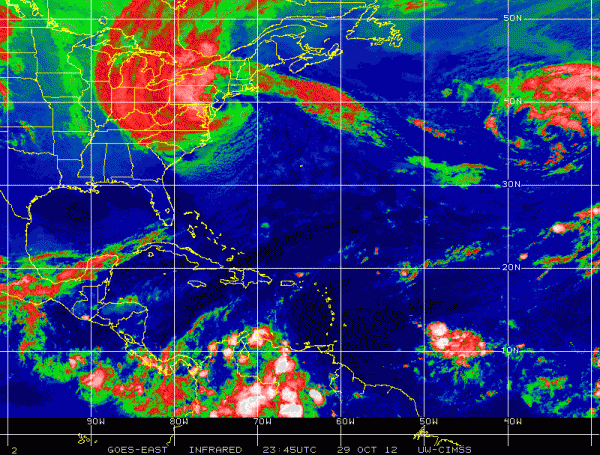
Weather experts agree that there has never been a storm like Hurricane Sandy in the history of modern meteorology.

How big is Sandy?

Sandy’s winds cover an area of more than 1,000 miles (1610 km) in diameter. Sandy now has the largest tropical storm-force wind field of any Atlantic tropical cyclone since 1988, topping Olga when it was a subtropical storm in 2001 according to Dr. Jeff Masters of Weather Underground. Olga’s winds extended out 600 miles (965 kilometers).
Let’s see some peak diameters of large hurricanes and their tropical wind extensions. Probably the largest was Isabel in 2003 which grew up to 575 miles (925 km) in diameter. Isabel’s hurricane-force wind field reached a diameter of 230 miles (370 km) before making landfall in September 2003. Hurricane Ike reached 485 miles (780 km) in diameter in 2008 and devastating Katrina peaked with 435 miles (700 km) in diameter in 2005. Last year, Irene’s wind field extended up to 460 miles (740 km) in diameter. Hurricane Sandy is wider and stronger than Hurricane Irene, which caused more than $15 billion in damage in 2011, and could rival the worst East Coast storm on record. Total damage from Hurricane Sandy may well exceed Katrina’s $96 billion. This could be the first $100+ billion storm in U.S. history.

Comparison of hurricanes Irene and Sandy captured by MODIS satellite
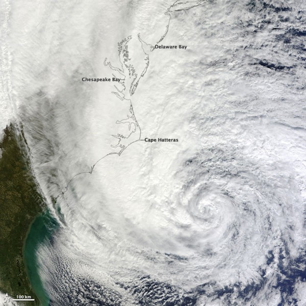
NASA's Terra satellite captured this image of Hurricane Sandy at 12 PM Eastern on Oct. 28, 2012.

Low pressure record

Sandy reached minimum central pressure of 938 mB. If Sandy reaches 934, she will be one of only 19 Atlantic hurricanes to achieve pressure that low, none of which had that pressure north of the Outer Banks. Northwest Atlantic pressure record is set by Hurricane Gladys in 1975, reaching 939 mB. According to AccuWeather Virginia, Maryland, Delaware and New Jersey would break their all-time pressure records. New York City, Block Island, RI and Nantucket, MA would break their all-time low pressure readings.
“Perfect Storm” of 1991 reached minimum central pressure of  972 mB. Great Blizzard of 1993 reached 960 mB and New England Hurricane, also known as Long Island Express of 1938,  reached 947 mB.

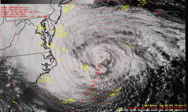
Suomi NPP Day/Night Band and 11.45 µm micron imagery of Hurricane Sandy
Watch here the satellite loop showing a series of full-resolution images taken one minute apart as Sandy approaches the East coast.
If this all happens as forecasted, and you and your family are stuck in the cold and dark without food and light and communications because you didn’t run to the store and get ready, excuses are going to be spectacularly hard to come by.” – Bryan Norcross, hurricane specialist for The Weather Channel

FORECAST

There will be some far-reaching effects aside from the most destructive impacts of storm surge flooding and high winds in the Northeast closer to the center of circulation. Sandy’s wind field will grow larger as the system begins to interact with a dip in the polar jet stream, deepening low pressure at the surface. It’s expected to change from a tropical storm powered by warm ocean water to something more like a winter storm powered by temperature and pressure differences in the atmosphere. Forecasters say Sandy may actually gain strength slightly as it reaches land, it will remain strong enough once on land to produce strong winds far inland. Wind damage will spread well inland, especially over higher terrain, due to the extremely large size of Sandy. In some areas, sustained winds of 30 to 50 mph could last for more than 24 hours. Gusts may top 80 mph in some locations. Lakeshore flood warnings have been hoisted on parts of the Great Lakes including Chicago.
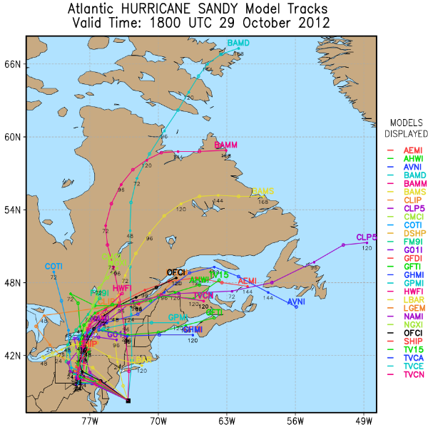
Cold Arctic air coming south from Canada also is expected to merge with Sandy, which will strengthen the storm further and create winter storm conditions. Sandy will bring cold air and snow as well as wind and rain. Forecasters expect Sandy to meet a mass of very cold air from a winter storm about the time it reaches land. This cold air will be incorporated into the hurricane, which means in some places torrential rains will be followed by temperatures in the 20s. Sandy is expected to produce two feet of snow or even more in parts of West Virginia. So the problems of extreme winter and summer weather will be wrapped into one storm.  The combination of snow and strong winds will damage trees and cause power outages. The heavy, wet nature of the snow could cause some structural damage and roof collapses. The snow will continue for several days wrapping around Sandy’s circulation as it winds down slowly.
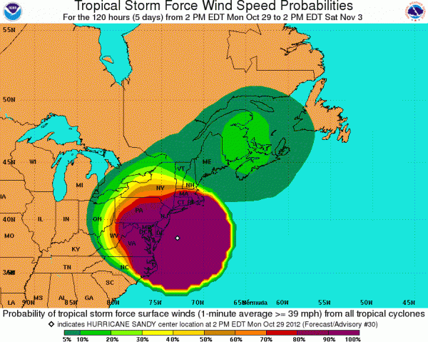
Heavy snow and strong winds will cause statewide power outages. Millions of people are expected to lose power at some point during Sandy and many will likely not have power restored for many days. That could be a major concern, especially in terms of heating.
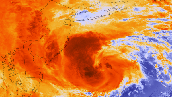
The most recent orbit from NOAA and NASA’s latest weather satellite, Suomi NPP, acquired at 1:35 pm ET on October 29, 2012, shows Hurricane Sandy as it approaches the U.S. coastline. (Credit: NASA/NOAA/VIIRS)
Tuesday, October 30, 2012

More about Sandy the Frankenstorm!

Hurricane Sandy Impacts 24 States: Map


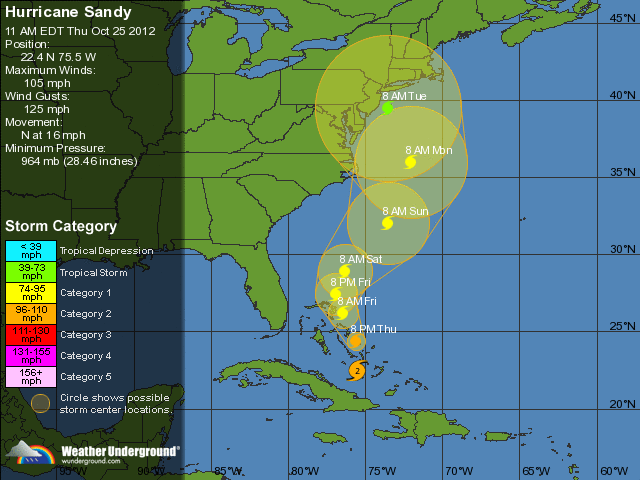
Frightening NWS Sandy Update Map: 5 Day Projection


~~~~~~~~~~~~~~~~~~~~~~~~~~~~~~~~~~~~~~~~~~~~~~~~~~~~~~~~~~~~~


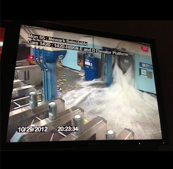
Water Pours into Hoboken Path Station: Don’t need to say much about this security camera.  It’s going to be quite a cleanup.


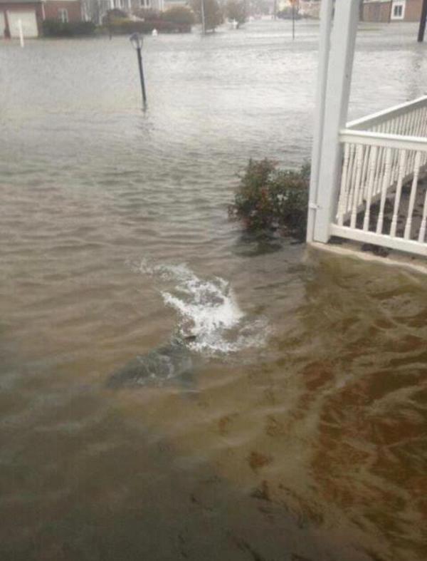
Sharks Swimming In NJ Now: I will admit, it is bad here! The wind has been non-stop and its’ been raining quite heavily, too. Still, at least I don’t have to look out my front door and see this!


Lights out, Manhattan. Creepy. From promenade. 

~~~~~~~~~~~~~~~~~~~~~~~~~~~~~~~~~~~~~~~~~~~~~~~~~~~~~~~~~~~~~


New York Subway Flooded
Superstorm Sandy slammed into the New Jersey coastline with 80 mph winds Monday night and hurled an unprecedented 13-foot surge of seawater at New York City, flooding its tunnels, subway stations and the electrical system that powers Wall Street. At least 13 U.S. deaths were blamed on the storm, which brought the presidential campaign to a halt a week before Election Day.

For New York City at least, Sandy was not the dayslong onslaught many had feared, and the wind and rain that sent water sloshing into Manhattan from three sides began dying down within hours.

Still, the power was out for hundreds of thousands of New Yorkers and an estimated 5.7 million people altogether across the East. And the full extent of the storm’s damage across the region was unclear, and unlikely to be known until daybreak.

In addition, heavy rain and further flooding remain major threats over the next couple of days as the storm makes its way into Pennsylvania and up into New York State. Near midnight, the center of the storm was just outside Philadelphia, and its winds were down to 75 mph, just barely hurricane strength.

“It was nerve-racking for a while, before the storm hit. Everything was rattling,” said Don Schweikert, who owns a bed-and-breakfast in Cape May, N.J., near where Sandy roared ashore. “I don’t see anything wrong, but I won’t see everything until morning.”

As the storm closed in, it converged with a cold-weather system that turned it into a superstorm, a monstrous hybrid consisting not only of rain and high wind but snow in West Virginia and other mountainous areas inland. 


~~~~~~~~~~~~~~~~~~~~~~~~~~~~~~~~~~~~~~~~~~~~~~~~~~~~~~~~~~~~~

A huge explosion has been filmed at a power plant in downtown Manhattan after Hurricane Sandy made landfall.


~~~~~~~~~~~~~~~~~~~~~~~~~~~~~~~~~~~~~~~~~~~~~~~~~~~~~~~~~~~~~


Meteorologist: Sandy Is Manufactured
Alex Jones welcomes meteorologist and award winning television weatherman Scott Stevens to explain how it’s possible that “Frankenstorm” Hurricane Sandy could be manipulated with military technology already at our disposal.


~~~~~~~~~~~~~~~~~~~~~~~~~~~~~~~~~~~~~~~~~~~~~~~~~~~~~~~~~~~~~


Hurricane Sandy Sinks HMS Bounty, 2 Missing

The crew aboard the HMS Bounty 90 miles southeast of Hatteras N.C., in the Atlantic Ocean had to abandon ship, according to the U.S. Coast Guard. Fourteen members crew were rescued from open water early Monday, while a few still remain missing.

The Coast Guard’s news release stated the life-jacket-wearing crew boarded two life boats among 18-foot seas with 40 mile per hour winds.

The Associated Press reported the crew being composed of 16 members, two of which remained missing. But the Facebook page for the ship says the crew included 17, meaning three would still be unaccounted for. The rescue took place at 6:30 a.m. Monday.


Latest Hurricane Sandy Satellite Photos

If you had any doubts about the scale of Frankenstorm Sandy, check out NASA's latest global Earth image to see its size compared to the entire planet. We are now updating this post with images, video and warnings from NASA, NOAA and other sources as they arrive.
Update 17: Latest update from the National Hurricane Center says the storm strength has increased. "The center is expected to landfall along or just south of southern New Jersey coast this evening or tonight."

New York is flooding already and the storm is NOT in full force yet. This one could really flood the subway system.

According to NOAA, "Sandy is expected to intensify as it interacts with an upper level system moving from the Great Lakes." The northeast region "may experience a widespread damaging storm, possibly of historic proportions".

The agency says "Sandy is expected to slam into the New Jersey coast later monday night, bringing heavy rain and damaging winds" to all areas. They warn that you shouldn't pay attention to the center of the storm, as all areas will have significant impact.

This is getting kind of scary—Sandy is hitting so hard that could really flood the New York City's subway system. Learn about it here

Parts of Manhattan, Brooklyn and Queens are already flooding and the storm isn't over the city in full force yet. That will happen around 4pm today. Take a look at these images, taken just a few minutes ago:

"The Hudson River has breached its banks 8.53 am" by Nigel Barker.

"East River rises above last two steps of Get Down, and approaches 3rd, at end of Wall Street"by Arturas Rosenbacher.

Here we are marooned in Red Hook, Brooklyn!!" by Greenpainting


The flooding in the Jamaica Bay, Queens neighborhood of Meadowmere. Courtesy of Kim Zatto, bait purveyor" by Corey Kilgannon.

Update 15: NASA's night shot, acquired by the Visible Infrared Imaging Radiometer Suite (VIIRS) on the Suomi NPP satellite around 2:42am EDT.

Update 14: NPR just reported that Starbucks have closed all its locations in NYC. How's that for a disaster? They also say this may be the biggest storm ever in the region.

Update 13: If you think Sandy is going to be just another Irene fizzle, think again; this animated GIF shows just how much stronger Sandy is at this stage in the game. And it's only getting stronger.


Friday, October 26, 2012

“Frankenstorm” Sandy: Man Made Monster Or An Act Of God?

Is Hurricane Sandy being steered to the East coast of the United States using the weather modification technique known as HAARP? The government has dubbed this storm ‘Frankenstorm’. Sure connotates a ‘man made monster’, doesn’t it? We’ve been reporting all week that HAARP has been nailing us here in the mid-Atlantic region up to New England.

From Yahoo:  Government forecasters say a big storm that they’re calling “Frankenstorm” is likely to blast most of the U.S. East Coast next week.


What they’re not telling you is that this was ‘the plan’, an epic storm that could put things all along the eastern seaboard ‘on hold’ for a while. Listen to the forecast below. The ‘perfect storm’ is approaching. Man made or an act of God? Buckle up! We could be in for a wild ride!