Showing posts with label hurricane. Show all posts

Thursday, November 29, 2012

When the Hard Times Come – You Are On Your Own!


by Earl Griffin

There has been a lot of attention paid recently to the activities of those individuals and families who believe in taking responsibility for themselves. Often they are called “Preppers.” Sometimes they are called “hoarders”, or “crazies.”

Funny; when things go south it’s not often you see those people on television crying, screaming, and pulling their hair because the government isn’t there to help them. That is because they helped themselves before it hit the fan.


I remember when Katrina hit the Gulf Coast. I recall the anger that I personally felt because of the seemingly unmitigated suffering of the people in the aftermath of that storm. Each day the smoldering rage I felt because of the government’s apparent inaction burned hotter and brighter.

It’s been several years since Katrina – things still haven’t gotten back to normal in New Orleans. “Those dang Republicans,” I thought, “callous, indifferent to the plight of those with whom they have lost touch.” 
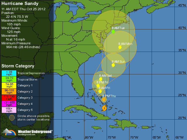
Now we’ve had another storm: Sandy.

The weather forecasters were united for a week. “It’s going to be a huge, terrible storm,” they said.

I remember the innumerable jackasses calling the radio station and complaining about the “hype.”

Before long reporters, weather forecasters, and government officials were making public service announcements to assure the public that this storm was not being “hyped.”
Everyone had a week’s warning!

The “crazies,” aka people who believe that it is their responsibility to take care of themselves and their own family no matter what, 
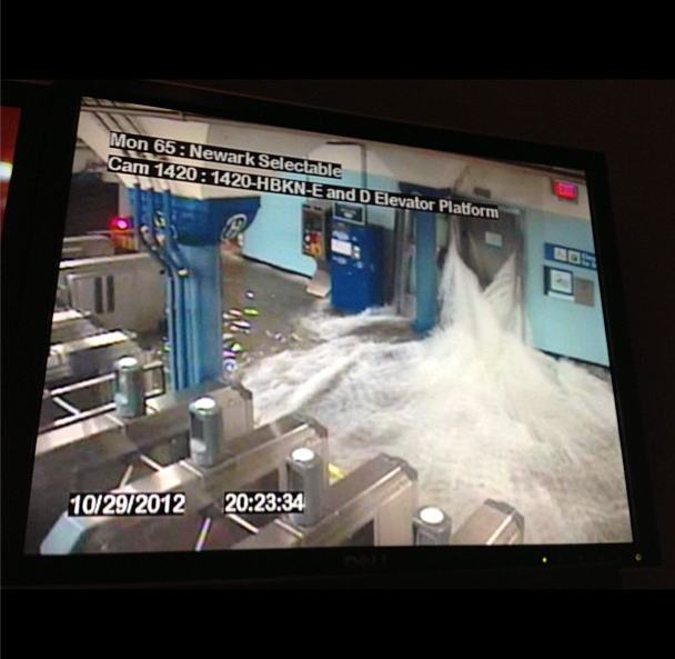
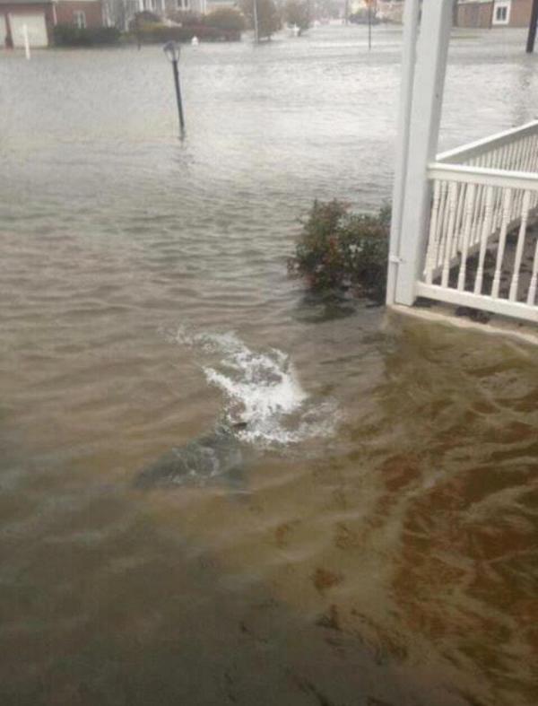
started getting ready as you can see: herehere, and here.

When I asked people, “What are you doing to get ready for Sandy?” A few people listed their preparations. However the majority of people just laughed at me and joked about, “Milk, bread, and toilet paper.”

Maryland was spared much of the terrible wind damage. However New Jersey and New York were not. Funny – at first there wasn’t a lot of coverage about the looting and panic people were experiencing. However, Barking Window did cover these things and more in Sandy’s aftermath.

We learned some startling truths. For instance FEMA simply isn’t ready for large disasters and it is Europe and not the U.S. that leads in weather forecasting.
The Republicans are not in charge this time around – instead it is a Democrat who sits in the White House. What difference did it make? It made no difference at all. People in those areas hardest hit by Sandy are all crying and begging for help – when they aren’t dumpster diving for food!

So the Republicans failed after Katrina and the Democrats have failed after Sandy.
There is an important lesson to learn from this: Reliance upon government is not a good idea during an emergency. People – all people – should prepare for hard times and emergencies within their means to do so! Even the poor can do something to prepare.
Prepare for the storm but also be mindful of your preparations for after the storm. You will have to look after yourself, your family, and even your neighbors. You will also have to be prepared for those who are up to no good.

There are a lot of people who will go on after this storm without having learned anything – don’t be one of them.

If you have not already done so, begin to develop a philosophy of self-reliance. Be careful though; don’t fall into the “me against the world,” snare that many others get caught in. Prepare for yourself and your family but don’t forget your neighbors. I don’t mean to suggest you should do their work for them, but I think it is important that we remember that we are not islands. We are members of a community. Reach out to those in need and be a leader in your community.

Sunday, November 11, 2012

FEMA Disaster Centers Shut Doors 'Due to Weather'


TOTTENVILLE — They fly into disaster areas, but flee from raindrops.

FEMA disaster recovery centers in Hurricane Sandy-ravaged sections of the city that were supposed to provide assistance to hurricane victims went MIA Wednesday morning, posting signs saying that they were closed due to the approaching Nor'easter.

The temporary shuttering of the facilities, which help victims register for disaster relief, as well as city food distribution centers come even as many of those still reeling from the monster storm were not told that they had to leave the battered areas.

“We do not believe that it’s necessary to evacuate people,” said the mayor Wednesday.

The move left residents of the storm-ravaged areas fuming.

"The storm is coming. We don't know how hard it's going to hit us," said Jenny Cartagena, 46, who found the FEMA center in Coney Island closed Wednesday when she went there looking for food. "I need some help now."

Because the FEMA centers were located with food distribution and warming services, some residents who arrived there were confused by the closed centers.

The city's food distribution centers, a lifeline for the thousands left without power, heat and water for more than a week, would only be operating until noon Wednesday, Mayor Michael Bloomberg announced.

And the National Guard, which was handing out food and water in Coney Island also shut down at 1:30 p.m. because of the weather, but continued handing out water to the line of approximately 30 people.

A spokemsan for the New York National Guard, Eric Durr, said that he could not comment on that specific instance but "we instructed our troops to pay attention to the weather and don’t take unecessary risks." Still, he said the guard would continue to provide relief as long as was needed.


In Staten Island, a printed paper sign taped to the front door of on the center at 6581 Hylan Blvd. at 10:30 a.m. read “FEMA Center Closed Due to Weather.”

The front doors of the disaster recovery center, which is housed inside the Mount Lorretto Catholic Youth Organization, were unlocked, but there was no staff anywhere in sight for at least a half an hour.

And a set of buses which served as a pair of warming centers at the site for the past several days were missing, according to non-FEMA volunteers who continued to hand out supplies from a nearby building despite the storm.

Volunteers at a nearby donation distribution center said the buses vanished on Wednesday.
“FEMA packed up and left,” said Louis Giraldi, 47, a volunteer handing out cleaning supplies to victims.

“We don’t know where they are, so there’s nothing here but us.”

The site is listed on FEMA's list of NYC recovery centers, and was supposed to be open from 8:30 a.m. to 8 p.m. Wednesday. The site was also included in the city's list of warming facilities supposed to open at 9 a.m. on Wednesday at the site.

A FEMA R/V also sat empty next to the recovery center.

A pair of FEMA workers alarmed by a reporter's camera came out of the building at 11 a.m. and took the sign down, saying the center reopen at 12:30 p.m. Wednesday.

The worker declined to give his name and would not explain why the site was closed or why the buses were missing.

FEMA spokesman Carter Langston said that the mobile centers were shuttered and staff moved inland because they were not structurally sound enough to weather the storm, which could put their staff in danger.

"Because these are mobile centers, they were shut down for life safety," Langston said. "As soon as weather permits tomorrow, they’re going to be back in place [possibly by noon]."
The remaining five sites in the city — in Staten Island, Coney Island, the Rockaways and The Bronx — were also closed or in the process of shutting down.

In Coney Island, a sign written in red ink that was bleeding from the rain sat on a police barrier in the parking lot of Our Lady of Solace Shrine Church on West 17th Street and Mermaid Avenue.

"They didn't want to get their precious van wet," quipped a church volunteer.

Cartagena, an asthma sufferer, said she showed up to the site with her home health aide, Camilla Suriel, 49, and her son's grandfather, Nelson Otero, 72 expecting "at least water."
"Something, you know, help," she said.

Volunteers at the church were still giving away water and MTA buses were on site to help people.

Serkan Yalcin, whose apartment in Sheepshead Bay was wrecked by Sandy, had a friend drop him off there.  He applied online for FEMA assistance last week, and came to the center today to follow up with an actual FEMA rep after his wife was not able to get through to reps.

"I would like to know if my application is in the system or not," he said. "Nobody has called or shown up."

The situation was similar in Queens, where thousands remain without power more than a week after Sandy.

At the FEMA site on Rockaway Point Boulevard, near Barrett Street, a sign read: “Operations stop [Tuesday] at 4 p.m. Closed Wednesday 7 Nov.”

The plan was to move the tent to the 99th Regional Support Command Center for Army reservists there, but because the building had no power the move could not be made until Thursday, a rep for the command center said.

Warren Lehner, 57, a project manager, lives right across the street from where the FEMA shelter has been registering hurricane victims the past 10 days, said he will likely need help for his parents, who have up to four feet of flooding in their home.

And he said with the nearly the entire peninsula going on their tenth day without power, food hard to come by, and water not running a large portion of the houses, the FEMA tents draw in much-needed volunteer efforts that established themselves around the relief centers.

“Now we got another storm coming in, where everyone’s going to be scrambling just to find a place they don’t freeze to death,” Lehner said. “Where are you going to go for a hot meal? It’s coming down to people just trying to survive, and that’s just not how it should be.”

Another location that was listed on FEMA's website on Beach 116th Street and Beach Channel Drive, showed no signs of the agency's presence.

At the city's Miller Field Distribution Center on New Dorp Lane in Staten Island, which houses a mobile FEMA disaster recovery center was also shutting down on Wednesday morning, a police car blocked the entrance at 11:35 a.m.

A cop said that officials were evacuating it because of the storm.

And in The Bronx, a FEMA tent and trailer sitting behind a volunteer firehouse on Adee Avenue in The Bronx was packed up Tuesday ahead of the storm.

"Theres's a ton of equipment you want to protect to make sure it's doing the most good wherever you take it," said Jim Garvey, of the Edgewater Athletic Association, which shares a building with the firehouse.

Read more: http://www.dnainfo.com/new-york/20121107/tottenville/staten-island-fema-disaster-center-shuts-doors-due-weather#ixzz2BebwZoFT

Thursday, November 1, 2012

How To Prepare For A Hurricane? Some Lessons That Preppers Can Learn From Hurricane Sandy

Here's an article on how to prepare for a hurricane like Sandy. Time to think more about how we can prepare for 2012...

~~~~~~~~~~~~~~~~~~~~~~~~~
If you are just starting to prepare for Hurricane Sandy, the truth is that you are already too late.  Most of the essential supplies have already been stripped from store shelves.  If you don't have an emergency generator, you might be without power for quite some time.  It is being estimated that up to 10 million people could lose power during this storm, and it is already being projected that some people may end up being without power for a week or more in the worst hit areas.  Hopefully you have already boarded up your windows.  They can be broken very easily during a hurricane, and you certainly don't want to be dealing with a broken window during the worst moments of the storm.  Those that have prepared ahead of time are likely to be in good shape to ride this storm out, but sadly the reality is that most people have not prepared ahead of time.  Every time a major storm or natural disaster strikes, we always see the same thing happen.  Hordes of half-crazed people storm into the stores hoping to find the things that they need, and many of them end up leaving disappointed because what they were looking for has already sold out.  Thankfully, most of our "disasters" have typically only lasted a few days at most, but what will happen someday if a disaster ends up being permanent?  What if there is a disaster that is so bad someday that things never return to "normal"?  Would you and your family be able to survive on only the preparations that you have made so far?
Hopefully Hurricane Sandy will be a wake up call for a whole lot of people.  It is being projected that this storm will affect about 50 million Americans, and it is already been called "worse than Katrina" by some meteorologists.  It is an absolutely gigantic storm.  It is more than 1000 miles across and it is the largest hurricane to hit the U.S. since records of storm size began to be kept back in 1988.  According to the National Oceanic and Atmospheric Administration, the destructive potential of this storm is rated 5.8 on a scale that goes from 0 to 6.  So needless to say, referring to this storm as "the Frankenstorm" does not quite do it justice.  It is being touted as the worst storm to hit the east coast in 100 years.
According to Stu Ostro, a senior meteorologist at the Weather Channel, this is truly a history making storm...
"History is being written as an extreme weather event continues to unfold, one which will occupy a place in the annals of weather history as one of the most extraordinary to have affected the United States."
So a lot of Americans are about to find out exactly how prepared they really are for a major natural disaster.
High winds of 80 MPH or higher are going to take down power lines all over the northeast over the next few days.  Along the coast, some people could see a storm surge that is up to 15 feet above sea level in some areas.  Other areas will see nightmarish flooding as a result of very heavy rain.
So there will certainly be a lot of challenges.  The good thing about a hurricane is that you typically have at least a few days in advance to make preparations.  Hopefully people have been making good use of the time.
Unfortunately, most Americans do not even have a short-term supply of food and water stored up.  A lot of people run out to grab some food and water from the stores at the last minute, only to find that there is none left.
For example, it is being reported that store shelves all over New York City have already been picked clean of bread and other essentials.
In Arlington, Virginia it is being reported that some supermarkets are already sold out of water.  If the worst happens and some people end up spending a week without tap water they are really going to wish that they had made some preparations ahead of time.
But food and water are not the only things in high demand.
According to CNN, other emergency supplies have been flying off the shelves as well...
Generators, flashlights, water, batteries -- these are just some of the emergency supplies that are running out in many stores in the Northeast.
Nearly a third of the country's northeast is preparing for Hurricane Sandy, which expected to make landfall on Sunday and Monday. Customers who have been flocking to stores may be coming home empty handed.
Fortunately this is only a temporary emergency, but what if we have a "permanent" emergency someday?
What will people do if they can't find the things that they desperately need all of a sudden?
According to Fox News, one store in Ohio is reporting that people are actually calling from other states to see if they still have any supplies...
An assistant manager at a Lowes store in Columbus, Ohio, told 10TV.com that people were calling in from West Virginia and Maryland to ask for supplies.
And in northern Virginia, a cashier at Pitkins Ace Hardware in Dale City said batteries, flashlights and candles were flying off the shelves, PotomacLocal.com reports.
When will people learn?
You don't wait until the last minute to get necessary emergency supplies like plywood, hurricane shutters, tarps, sump pumps, ice chests, candles, flashlights, batteries and battery-powered radios.
For a hurricane, you need to be prepared to be able to survive for at least a week without any help from the outside world.  In the most extreme situations (such as in the aftermath of Hurricane Katrina) the state of emergency created by a hurricane can last even longer.
So exactly how should one prepare for a hurricane?
Ready.gov provides the following list of tips...
To prepare for a hurricane, you should take the following measures:
  • To begin preparing, you should build an emergency kit and make a family communications plan.
  • Know your surroundings.
  • Learn the elevation level of your property and whether the land is flood-prone. This will help you know how your property will be affected when storm surge or tidal flooding are forecasted.
  • Identify levees and dams in your area and determine whether they pose a hazard to you.
  • Learn community hurricane evacuation routes and how to find higher ground. Determine where you would go and how you would get there if you needed to evacuate.
  • Make plans to secure your property:
  • Cover all of your home’s windows. Permanent storm shutters offer the best protection for windows. A second option is to board up windows with 5/8” marine plywood, cut to fit and ready to install. Tape does not prevent windows from breaking.
  • Install straps or additional clips to securely fasten your roof to the frame structure. This will reduce roof damage.
  • Be sure trees and shrubs around your home are well trimmed so they are more wind resistant.
  • Clear loose and clogged rain gutters and downspouts.
  • Reinforce your garage doors; if wind enters a garage it can cause dangerous and expensive structural damage.
  • Plan to bring in all outdoor furniture, decorations, garbage cans and anything else that is not tied down.
  • Determine how and where to secure your boat.
  • Install a generator for emergencies.
  • If in a high-rise building, be prepared to take shelter on or below the 10th floor.
  • Consider building a safe room.
A recent CNN article included a list of supplies that you should have on hand in the event that a hurricane is on the way...
-- A three-day supply of water, one gallon per person per day.
-- Three days of food, with suggested items including: canned meats, canned or dried fruits, canned vegetables, canned juice, peanut butter, jelly, salt-free crackers, energy/protein bars, trail mix/nuts, dry cereal, cookies or other comfort food.
-- A can opener.
-- Flashlight(s).
-- A battery-powered radio, preferably a weather radio.
-- Extra batteries.
-- A first aid kit, including latex gloves; sterile dressings; soap/cleaning agent; antibiotic ointment; burn ointment; adhesive bandages in small, medium and large sizes; eye wash; a thermometer; aspirin/pain reliever; anti-diarrhea tablets; antacids; laxatives; small scissors; tweezers; petroleum jelly.
-- A small fire extinguisher.
-- Whistles for each person.
-- A seven-day supply of medications.
-- Vitamins.
-- A multipurpose tool, with pliers and a screwdriver.
-- Cell phones and chargers.
-- Contact information for the family.
-- A sleeping bag for each person.
-- Extra cash.
-- A silver foil emergency blanket.
-- A map of the area.
-- Baby supplies.
-- Pet supplies.
-- Wet wipes.
-- A camera (to document storm damage).
-- Insect repellent.
-- Rain gear.
-- Tools and supplies for securing your home.
-- Plastic sheeting.
-- Duct tape.
-- Dust masks.
-- An extra set of house keys.
-- An extra set of car keys.
-- An emergency ladder to evacuate the second floor.
-- Household bleach.
-- Paper cups, plates and paper towels.
-- Activities for children.
-- Charcoal and matches, if you have a portable grill. But only use it outside.
But in the final analysis, preparation is going to look a little bit different for every family.
If you live along the coast, there is a good chance that you will need to evacuate.  If you live farther inland, you will probably be able to hunker down exactly where you are.
Hurricane Sandy will come and go, but hopefully millions of Americans will learn some lessons about preparation from this crisis.  One of these days we may have a disaster that lasts much longer such as a major economic crisis, an EMP attack, a nightmarish pandemic or a major war.  If we cannot handle a disaster that lasts for just a couple of days, what chance are we going to have at surviving something that lasts for months or even years?
That is something to think about.  Hopefully we will all reflect on emergency preparedness over the next few days.  Our world is becoming increasingly unstable, and eventually there will come a point where we will find ourselves totally dependent on the preparations that we have made.

Wednesday, October 31, 2012

How big and serious is Sandy and why?

More at: http://thewatchers.adorraeli.com/2012/10/30/how-big-hurricane-sandy/


Sandy is now post-tropical cyclone. Regardless its hurricane status, Sandy, dubbed Frankenstorm, is a massive system that will affect a huge swath of the eastern U.S. It is now evident that it may become the biggest storm of century. The circulation of Sandy could cover each of the 26 states east of the Mississippi River by Tuesday! Winds and clouds from Hurricane Sandy could stretch across the eastern third of the United States, according to weather predictions from the National Hurricane Center (NHC).

Sandy’s main features

Sandy is morphing from a tropical cyclone to an extra-tropical cyclone which tend to be significantly larger than tropical ones. Extra-tropical cyclones are driven by a difference in temperatures over a wide area— cold air to the northwest, warm air to the southeast, which then swirls together. Hurricane Sandy formed as a tropical cyclone, fueled by warm waters and warm  moisty air. Ample warm, moist air in the western Caribbean allowed Sandy to grow into a tropical cyclone and hurricane shortly after.
Dawn to Dusk: Hurricane Sandy, October 28, 2012, Super Rapid Scan
This time-lapse animation above shows Hurricane Sandy from the vantage point of geostationary orbit—35,800 km (22,300 miles) above the Earth on October 28, 2012. Light from the changing angles of the sun highlight the structure of the clouds. The images were collected by NOAA’s GOES-14 satellite. The “super rapid scan” images—one every minute, reveal details of the storm’s motion.
The video above shows Hurricane Sandy’s development on October 29, recorded from 11:15:00 UTC till 21:21:00 UTC.
Sandy is progressing into an extra-tropical cyclone as it gets farther north, and tapping into the power of the jet stream, which ferries air from west to east over North America. The jet stream, like the storm itself, is powered by this temperature difference between air masses, according to  Chris Davis, a scientist with the University Corporation for Atmospheric Research in Boulder, Colorado. Sandy is also deriving power from the movement of warm air to the north and cold air to the south, similar in some respects to the Perfect Storm of 1991. What we are seeing now from Sandy is a rare mix of a hurricane and a cold front jet stream. The upper level wind  is merging with the tropical system creating a “monstrous hybrid vortex” – a combination of a hurricane and a nor’easter according to Weather Channel hurricane specialist Bryan Norcross.
Weather experts agree that there has never been a storm like Hurricane Sandy in the history of modern meteorology.

How big is Sandy?

Sandy’s winds cover an area of more than 1,000 miles (1610 km) in diameter. Sandy now has the largest tropical storm-force wind field of any Atlantic tropical cyclone since 1988, topping Olga when it was a subtropical storm in 2001 according to Dr. Jeff Masters of Weather Underground. Olga’s winds extended out 600 miles (965 kilometers).
Let’s see some peak diameters of large hurricanes and their tropical wind extensions. Probably the largest was Isabel in 2003 which grew up to 575 miles (925 km) in diameter. Isabel’s hurricane-force wind field reached a diameter of 230 miles (370 km) before making landfall in September 2003. Hurricane Ike reached 485 miles (780 km) in diameter in 2008 and devastating Katrina peaked with 435 miles (700 km) in diameter in 2005. Last year, Irene’s wind field extended up to 460 miles (740 km) in diameter. Hurricane Sandy is wider and stronger than Hurricane Irene, which caused more than $15 billion in damage in 2011, and could rival the worst East Coast storm on record. Total damage from Hurricane Sandy may well exceed Katrina’s $96 billion. This could be the first $100+ billion storm in U.S. history.

Comparison of hurricanes Irene and Sandy captured by MODIS satellite

NASA's Terra satellite captured this image of Hurricane Sandy at 12 PM Eastern on Oct. 28, 2012.

Low pressure record

Sandy reached minimum central pressure of 938 mB. If Sandy reaches 934, she will be one of only 19 Atlantic hurricanes to achieve pressure that low, none of which had that pressure north of the Outer Banks. Northwest Atlantic pressure record is set by Hurricane Gladys in 1975, reaching 939 mB. According to AccuWeather Virginia, Maryland, Delaware and New Jersey would break their all-time pressure records. New York City, Block Island, RI and Nantucket, MA would break their all-time low pressure readings.
“Perfect Storm” of 1991 reached minimum central pressure of  972 mB. Great Blizzard of 1993 reached 960 mB and New England Hurricane, also known as Long Island Express of 1938,  reached 947 mB.

Suomi NPP Day/Night Band and 11.45 µm micron imagery of Hurricane Sandy
Watch here the satellite loop showing a series of full-resolution images taken one minute apart as Sandy approaches the East coast.
If this all happens as forecasted, and you and your family are stuck in the cold and dark without food and light and communications because you didn’t run to the store and get ready, excuses are going to be spectacularly hard to come by.” – Bryan Norcross, hurricane specialist for The Weather Channel

FORECAST

There will be some far-reaching effects aside from the most destructive impacts of storm surge flooding and high winds in the Northeast closer to the center of circulation. Sandy’s wind field will grow larger as the system begins to interact with a dip in the polar jet stream, deepening low pressure at the surface. It’s expected to change from a tropical storm powered by warm ocean water to something more like a winter storm powered by temperature and pressure differences in the atmosphere. Forecasters say Sandy may actually gain strength slightly as it reaches land, it will remain strong enough once on land to produce strong winds far inland. Wind damage will spread well inland, especially over higher terrain, due to the extremely large size of Sandy. In some areas, sustained winds of 30 to 50 mph could last for more than 24 hours. Gusts may top 80 mph in some locations. Lakeshore flood warnings have been hoisted on parts of the Great Lakes including Chicago.
Cold Arctic air coming south from Canada also is expected to merge with Sandy, which will strengthen the storm further and create winter storm conditions. Sandy will bring cold air and snow as well as wind and rain. Forecasters expect Sandy to meet a mass of very cold air from a winter storm about the time it reaches land. This cold air will be incorporated into the hurricane, which means in some places torrential rains will be followed by temperatures in the 20s. Sandy is expected to produce two feet of snow or even more in parts of West Virginia. So the problems of extreme winter and summer weather will be wrapped into one storm.  The combination of snow and strong winds will damage trees and cause power outages. The heavy, wet nature of the snow could cause some structural damage and roof collapses. The snow will continue for several days wrapping around Sandy’s circulation as it winds down slowly.
Heavy snow and strong winds will cause statewide power outages. Millions of people are expected to lose power at some point during Sandy and many will likely not have power restored for many days. That could be a major concern, especially in terms of heating.

The most recent orbit from NOAA and NASA’s latest weather satellite, Suomi NPP, acquired at 1:35 pm ET on October 29, 2012, shows Hurricane Sandy as it approaches the U.S. coastline. (Credit: NASA/NOAA/VIIRS)

Tuesday, October 30, 2012

More about Sandy the Frankenstorm!

Hurricane Sandy Impacts 24 States: Map


Frightening NWS Sandy Update Map: 5 Day Projection


~~~~~~~~~~~~~~~~~~~~~~~~~~~~~~~~~~~~~~~~~~~~~~~~~~~~~~~~~~~~~


Water Pours into Hoboken Path Station: Don’t need to say much about this security camera.  It’s going to be quite a cleanup.


Sharks Swimming In NJ Now: I will admit, it is bad here! The wind has been non-stop and its’ been raining quite heavily, too. Still, at least I don’t have to look out my front door and see this!


Lights out, Manhattan. Creepy. From promenade. 

~~~~~~~~~~~~~~~~~~~~~~~~~~~~~~~~~~~~~~~~~~~~~~~~~~~~~~~~~~~~~


New York Subway Flooded
Superstorm Sandy slammed into the New Jersey coastline with 80 mph winds Monday night and hurled an unprecedented 13-foot surge of seawater at New York City, flooding its tunnels, subway stations and the electrical system that powers Wall Street. At least 13 U.S. deaths were blamed on the storm, which brought the presidential campaign to a halt a week before Election Day.

For New York City at least, Sandy was not the dayslong onslaught many had feared, and the wind and rain that sent water sloshing into Manhattan from three sides began dying down within hours.

Still, the power was out for hundreds of thousands of New Yorkers and an estimated 5.7 million people altogether across the East. And the full extent of the storm’s damage across the region was unclear, and unlikely to be known until daybreak.

In addition, heavy rain and further flooding remain major threats over the next couple of days as the storm makes its way into Pennsylvania and up into New York State. Near midnight, the center of the storm was just outside Philadelphia, and its winds were down to 75 mph, just barely hurricane strength.

“It was nerve-racking for a while, before the storm hit. Everything was rattling,” said Don Schweikert, who owns a bed-and-breakfast in Cape May, N.J., near where Sandy roared ashore. “I don’t see anything wrong, but I won’t see everything until morning.”

As the storm closed in, it converged with a cold-weather system that turned it into a superstorm, a monstrous hybrid consisting not only of rain and high wind but snow in West Virginia and other mountainous areas inland. 


~~~~~~~~~~~~~~~~~~~~~~~~~~~~~~~~~~~~~~~~~~~~~~~~~~~~~~~~~~~~~

A huge explosion has been filmed at a power plant in downtown Manhattan after Hurricane Sandy made landfall.


~~~~~~~~~~~~~~~~~~~~~~~~~~~~~~~~~~~~~~~~~~~~~~~~~~~~~~~~~~~~~


Meteorologist: Sandy Is Manufactured
Alex Jones welcomes meteorologist and award winning television weatherman Scott Stevens to explain how it’s possible that “Frankenstorm” Hurricane Sandy could be manipulated with military technology already at our disposal.


~~~~~~~~~~~~~~~~~~~~~~~~~~~~~~~~~~~~~~~~~~~~~~~~~~~~~~~~~~~~~


Hurricane Sandy Sinks HMS Bounty, 2 Missing

The crew aboard the HMS Bounty 90 miles southeast of Hatteras N.C., in the Atlantic Ocean had to abandon ship, according to the U.S. Coast Guard. Fourteen members crew were rescued from open water early Monday, while a few still remain missing.

The Coast Guard’s news release stated the life-jacket-wearing crew boarded two life boats among 18-foot seas with 40 mile per hour winds.

The Associated Press reported the crew being composed of 16 members, two of which remained missing. But the Facebook page for the ship says the crew included 17, meaning three would still be unaccounted for. The rescue took place at 6:30 a.m. Monday.


Latest Hurricane Sandy Satellite Photos

If you had any doubts about the scale of Frankenstorm Sandy, check out NASA's latest global Earth image to see its size compared to the entire planet. We are now updating this post with images, video and warnings from NASA, NOAA and other sources as they arrive.
Update 17: Latest update from the National Hurricane Center says the storm strength has increased. "The center is expected to landfall along or just south of southern New Jersey coast this evening or tonight."

New York is flooding already and the storm is NOT in full force yet. This one could really flood the subway system.

According to NOAA, "Sandy is expected to intensify as it interacts with an upper level system moving from the Great Lakes." The northeast region "may experience a widespread damaging storm, possibly of historic proportions".

The agency says "Sandy is expected to slam into the New Jersey coast later monday night, bringing heavy rain and damaging winds" to all areas. They warn that you shouldn't pay attention to the center of the storm, as all areas will have significant impact.

This is getting kind of scary—Sandy is hitting so hard that could really flood the New York City's subway system. Learn about it here

Parts of Manhattan, Brooklyn and Queens are already flooding and the storm isn't over the city in full force yet. That will happen around 4pm today. Take a look at these images, taken just a few minutes ago:

"The Hudson River has breached its banks 8.53 am" by Nigel Barker.

"East River rises above last two steps of Get Down, and approaches 3rd, at end of Wall Street"by Arturas Rosenbacher.

Here we are marooned in Red Hook, Brooklyn!!" by Greenpainting


The flooding in the Jamaica Bay, Queens neighborhood of Meadowmere. Courtesy of Kim Zatto, bait purveyor" by Corey Kilgannon.

Update 15: NASA's night shot, acquired by the Visible Infrared Imaging Radiometer Suite (VIIRS) on the Suomi NPP satellite around 2:42am EDT.

Update 14: NPR just reported that Starbucks have closed all its locations in NYC. How's that for a disaster? They also say this may be the biggest storm ever in the region.

Update 13: If you think Sandy is going to be just another Irene fizzle, think again; this animated GIF shows just how much stronger Sandy is at this stage in the game. And it's only getting stronger.


Friday, October 26, 2012

“Frankenstorm” Sandy: Man Made Monster Or An Act Of God?

Is Hurricane Sandy being steered to the East coast of the United States using the weather modification technique known as HAARP? The government has dubbed this storm ‘Frankenstorm’. Sure connotates a ‘man made monster’, doesn’t it? We’ve been reporting all week that HAARP has been nailing us here in the mid-Atlantic region up to New England.

From Yahoo:  Government forecasters say a big storm that they’re calling “Frankenstorm” is likely to blast most of the U.S. East Coast next week.


What they’re not telling you is that this was ‘the plan’, an epic storm that could put things all along the eastern seaboard ‘on hold’ for a while. Listen to the forecast below. The ‘perfect storm’ is approaching. Man made or an act of God? Buckle up! We could be in for a wild ride!