
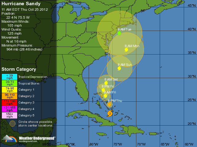
Frightening NWS Sandy Update Map: 5 Day Projection

~~~~~~~~~~~~~~~~~~~~~~~~~~~~~~~~~~~~~~~~~~~~~~~~~~~~~~~~~~~~~
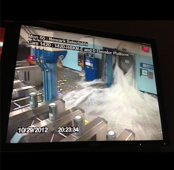
Water Pours into Hoboken Path Station: Don’t need to say much about this security camera. It’s going to be quite a cleanup.
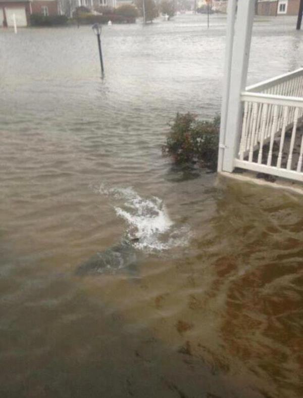
Sharks Swimming In NJ
Now: I will admit, it is bad here! The wind has been non-stop and its’ been
raining quite heavily, too. Still, at least I don’t have to look out my front
door and see this!
Lights out, Manhattan. Creepy. From promenade.
.jpg)
~~~~~~~~~~~~~~~~~~~~~~~~~~~~~~~~~~~~~~~~~~~~~~~~~~~~~~~~~~~~~
New York Subway Flooded
Superstorm Sandy slammed into the New Jersey coastline with
80 mph winds Monday night and hurled an unprecedented 13-foot surge of seawater
at New York City, flooding its tunnels, subway stations and the electrical
system that powers Wall Street. At least 13 U.S. deaths were blamed on the
storm, which brought the presidential campaign to a halt a week before Election
Day.
For New York City at least, Sandy was not the dayslong
onslaught many had feared, and the wind and rain that sent water sloshing into
Manhattan from three sides began dying down within hours.
Still, the power was out for hundreds of thousands of New
Yorkers and an estimated 5.7 million people altogether across the East. And the
full extent of the storm’s damage across the region was unclear, and unlikely
to be known until daybreak.
In addition, heavy rain and further flooding remain major
threats over the next couple of days as the storm makes its way into
Pennsylvania and up into New York State. Near midnight, the center of the storm
was just outside Philadelphia, and its winds were down to 75 mph, just barely
hurricane strength.
“It was nerve-racking for a while, before the storm hit.
Everything was rattling,” said Don Schweikert, who owns a bed-and-breakfast in
Cape May, N.J., near where Sandy roared ashore. “I don’t see anything wrong,
but I won’t see everything until morning.”
As the storm closed in, it converged with a cold-weather
system that turned it into a superstorm, a monstrous hybrid consisting not only
of rain and high wind but snow in West Virginia and other mountainous areas
inland.
More: http://www.deseretnews.com/article/765614160/Sandy-causes-NJ-flooding-power-outages-2-deaths.html

~~~~~~~~~~~~~~~~~~~~~~~~~~~~~~~~~~~~~~~~~~~~~~~~~~~~~~~~~~~~~
A huge explosion has been filmed at a power plant in downtown Manhattan after Hurricane Sandy made landfall.
Meteorologist: Sandy Is Manufactured
Alex Jones welcomes meteorologist and award winning
television weatherman Scott Stevens to explain how it’s possible that
“Frankenstorm” Hurricane Sandy could be manipulated with military technology
already at our disposal.
~~~~~~~~~~~~~~~~~~~~~~~~~~~~~~~~~~~~~~~~~~~~~~~~~~~~~~~~~~~~~
Hurricane Sandy Sinks
HMS Bounty, 2 Missing
The crew aboard the HMS Bounty 90 miles southeast of
Hatteras N.C., in the Atlantic Ocean had to abandon ship, according to the U.S.
Coast Guard. Fourteen members crew were rescued from open water early Monday,
while a few still remain missing.
The Coast Guard’s news release stated the
life-jacket-wearing crew boarded two life boats among 18-foot seas with 40 mile
per hour winds.
The Associated Press reported the crew being composed of 16
members, two of which remained missing. But the Facebook page for the ship says
the crew included 17, meaning three would still be unaccounted for. The rescue
took place at 6:30 a.m. Monday.


.jpg)