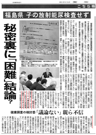
“Considering the potential spread of WBC (Whole body
counter) and the fact that germanium semiconductor detector is in excessive
demand such as for beef, it is impossible to replace WBC with urine test.”
WBC is the equipment to detect gamma ray from cesium taken
in body. Because it lacks accuracy and requires the testee to stay still for
long time, it is not suitable for children. Urine test with germanium
semiconductor detector analyzes more accurately.
However, because they wanted to use germanium
semiconductor detector for the radiation test of beef, they decided not to
conduct urine test of the children.
Frightening NWS Sandy Update Map: 5 Day Projection
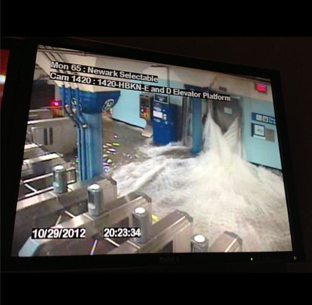
~~~~~~~~~~~~~~~~~~~~~~~~~~~~~~~~~~~~~~~~~~~~~~~~~~~~~~~~~~~~~ Water Pours into Hoboken Path Station: Don’t need to say much about this security camera.
It’s going to be quite a cleanup.
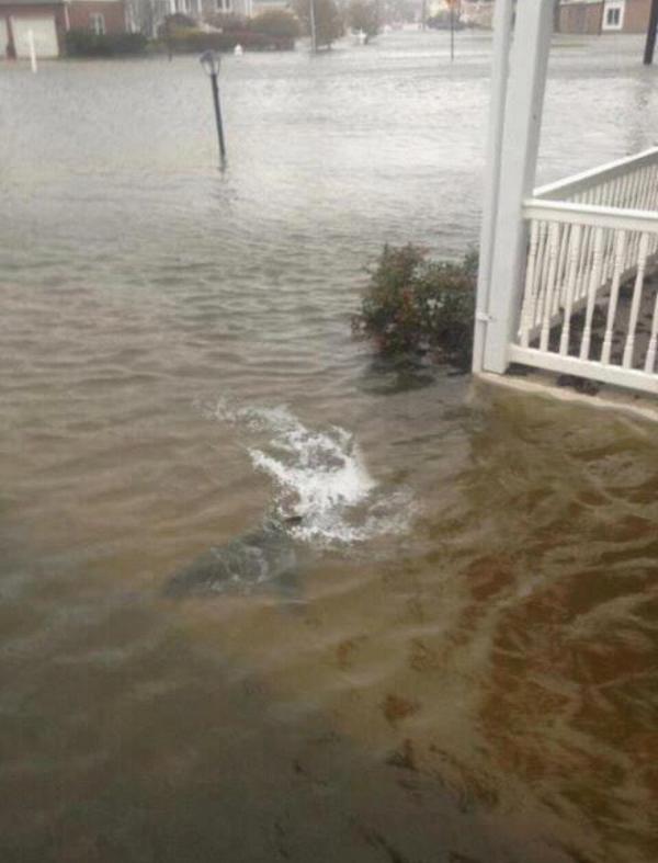
Sharks Swimming In NJ
Now: I will admit, it is bad here! The wind has been non-stop and its’ been
raining quite heavily, too. Still, at least I don’t have to look out my front
door and see this!
Superstorm Sandy slammed into the New Jersey coastline with
80 mph winds Monday night and hurled an unprecedented 13-foot surge of seawater
at New York City, flooding its tunnels, subway stations and the electrical
system that powers Wall Street. At least 13 U.S. deaths were blamed on the
storm, which brought the presidential campaign to a halt a week before Election
Day.
For New York City at least, Sandy was not the dayslong
onslaught many had feared, and the wind and rain that sent water sloshing into
Manhattan from three sides began dying down within hours.
Still, the power was out for hundreds of thousands of New
Yorkers and an estimated 5.7 million people altogether across the East. And the
full extent of the storm’s damage across the region was unclear, and unlikely
to be known until daybreak.
In addition, heavy rain and further flooding remain major
threats over the next couple of days as the storm makes its way into
Pennsylvania and up into New York State. Near midnight, the center of the storm
was just outside Philadelphia, and its winds were down to 75 mph, just barely
hurricane strength.
“It was nerve-racking for a while, before the storm hit.
Everything was rattling,” said Don Schweikert, who owns a bed-and-breakfast in
Cape May, N.J., near where Sandy roared ashore. “I don’t see anything wrong,
but I won’t see everything until morning.”
As the storm closed in, it converged with a cold-weather
system that turned it into a superstorm, a monstrous hybrid consisting not only
of rain and high wind but snow in West Virginia and other mountainous areas
inland.
~~~~~~~~~~~~~~~~~~~~~~~~~~~~~~~~~~~~~~~~~~~~~~~~~~~~~~~~~~~~~
A huge explosion has been filmed at a power plant in
downtown Manhattan after Hurricane Sandy made landfall.
Alex Jones welcomes meteorologist and award winning
television weatherman Scott Stevens to explain how it’s possible that
“Frankenstorm” Hurricane Sandy could be manipulated with military technology
already at our disposal.
The crew aboard the HMS Bounty 90 miles southeast of
Hatteras N.C., in the Atlantic Ocean had to abandon ship, according to the U.S.
Coast Guard. Fourteen members crew were rescued from open water early Monday,
while a few still remain missing.
The Coast Guard’s news release stated the
life-jacket-wearing crew boarded two life boats among 18-foot seas with 40 mile
per hour winds.
The Associated Press reported the crew being composed of 16
members, two of which remained missing. But the Facebook page for the ship says
the crew included 17, meaning three would still be unaccounted for. The rescue
took place at 6:30 a.m. Monday.
If you had any doubts about the scale of Frankenstorm Sandy, check
out NASA's latest global Earth image to see its size compared to the
entire planet. We are now updating this post with images, video and warnings
from NASA, NOAA and other sources as they arrive.
Update 17: Latest
update from the National Hurricane Center says the storm strength has
increased. "The center is expected to landfall along or just south of
southern New Jersey coast this evening or tonight."
According to NOAA, "Sandy is expected to intensify as
it interacts with an upper level system moving from the Great Lakes." The
northeast region "may experience a widespread damaging storm,
possibly of historic proportions".
The agency says "Sandy is expected to slam into the New
Jersey coast later monday night, bringing heavy rain and damaging winds"
to all areas. They
warn that you shouldn't pay attention to the center of the storm, as
all areas will have significant impact.
This is getting kind of scary—Sandy is hitting so hard that
could really flood the New York City's subway system. Learn
about it here
Parts of Manhattan, Brooklyn and Queens are already flooding
and the storm isn't over the city in full force yet. That will happen around
4pm today. Take a look at these images, taken just a few minutes ago:
"The Hudson River has
breached its banks 8.53 am" by Nigel
Barker.
"East
River rises above last two steps of Get Down, and approaches 3rd, at end of
Wall Street"by Arturas
Rosenbacher.
The flooding in the Jamaica Bay, Queens neighborhood of
Meadowmere. Courtesy of Kim Zatto, bait purveyor" by Corey
Kilgannon.
Update 15: NASA's
night shot, acquired by the Visible Infrared Imaging Radiometer Suite
(VIIRS) on the Suomi NPP satellite around 2:42am EDT.
Update 14: NPR just reported that Starbucks have closed all
its locations in NYC. How's that for a disaster? They also say this may be the
biggest storm ever in the region.
Update 13: If you think Sandy is going to be just another
Irene fizzle, think again; this
animated GIF shows just how much stronger Sandy is at this stage in
the game. And it's only getting stronger.
Tsunami warnings prompted by a 7.7 earthquake off the
Canadian coast on Friday caused more than 100,000 people to flee from Hawaiian
shores to higher ground in the state late on Saturday evening, but the
evacuation order was canceled after a series of smaller than expected waves
crashed on the islands The tsunami was unusual in that it came from the
east, an ocurrence that had not been observed for hundreds of years.
Geologists say the 7.7 quake could be a precursor to a larger earthquake
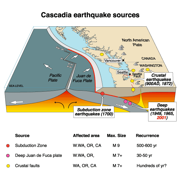
but there is no way of knowing. The Canadian quake was in the Cascadia
earthquake zone.
A tsunami was generated that could have caused damage along
coastlines of all islands in the state of Hawaii. Urgent action was urged
yesterday to protect lives and property.
The 1700 Cascadia earthquake was a magnitude 8.7 to 9.2
megathrust earthquake that occurred in the Cascadia subduction zone on January
26, 1700. The earthquake involved the Juan de Fuca Plate underlying the Pacific
Ocean, from mid-Vancouver Island in British Columbia, Canada, south along the
Pacific Northwest coast as far as northern California, USA. The length of the
fault rupture was about 1,000 kilometers (620 miles) with an average slip of 20
meters (22 yards).
The earthquake caused a tsunami that struck the coast of
Japan and Hawaii and may also be linked to the Bonneville Slide.
A tsunami is a series of long ocean waves. Each individual
wave crest can last 5 to 15 minutes or more and extensively flood coastal
areas. The danger can continue for many hours after the initial wave as
subsequent waves arrive. Tsunami wave heights cannot be predicted and the
first wave may not be the largest.
The geological record reveals that “great earthquakes”
(those with moment magnitude 8 or higher) occur in the Cascadia subduction zone
about every 500 years on average, often accompanied by tsunamis. There is
evidence of at least 13 events at intervals from about 300 to 900 years with an
average of 570—590 years. Previous earthquakes are estimated to have occurred
in 1310 AD, 810 AD, 400 AD, 170 BC and 600 BC.
Credit: Wikipedia
As seen in the 1700 quake, the 2004 Indian Ocean earthquake,
and the 2011 Tōhoku earthquake, subduction zone earthquakes can cause large
tsunamis, and many coastal areas in the region have prepared tsunami evacuation
plans in anticipation of a possible future Cascadia earthquake. However, the
major nearby cities, notably Seattle, Portland, Vancouver, Victoria, and
Tacoma, which are located on inland waterways rather than on the coast, would
be sheltered from the full brunt of a tsunami. These cities do have many
vulnerable structures, especially bridges and unreinforced brick buildings;
consequently, most of the damage to the cities would probably be from the
earthquake itself. One expert asserts that buildings in Seattle are vastly
inadequate even to withstand an earthquake of the size of the 1906 San
Francisco earthquake, much less the much greater one that may well occur.[7]
Recent findings conclude that the Cascadia Subduction zone
is more complex and volatile than previously believed. In 2010 geologists
predicted a 37 percent chance of an M8.2+ event within 50 years, and a 10 to 15
percent chance that the entire Cascadia Subduction will rupture with an M9+
event within the same time frame. Geologists have also determined the Pacific
Northwest is not prepared for such a colossal quake. The tsunami produced could
reach heights of 80 to 100 feet (24 to 30 m).
Some other subduction zones have such earthquakes every 100
to 200 years; the longer interval results from slower plate motions. The rate
of convergence between the Juan de Fuca Plate and the North American Plate is
60 millimetres (2.4 in) per year.
Tsunami waves efficiently wrap around islands. All
shores are at risk no matter which direction they face. The trough of a tsunami
wave may temporarily expose the seafloor but the area will quickly flood again.
Extremely strong and unusual nearshore currents can accompany a tsunami. Debris
picked up and carried by a tsunami amplifies its destructive power.
Simultaneous high tides or high surf can significantly increase the tsunami
hazard. The estimated arrival time in Hawaii of the first tsunami wave is
1028 pm hst sat 27 oct 2012
139 km (86 miles) S of Masset, Canada 202 km (125 miles) SSW of Prince Rupert, Canada 293 km (182 miles) SW of Terrace, Canada 556 km (345 miles) NW of Campbell River, Canada
In the Old Testament, God had asked Moses to tell the
Israelites that they should celebrate seven feasts to God every year. They are:
Turnover, the Feast of Unleavened Bread, Shavuot, Pentecost, the
Feast of Trumpets, Day of Atonement and the Feast of Tabernacles.
In the New Testament, in the books of Colossians and
Hebrews, Paul mentioned that the Old Testament is the shadow of the New Testament.
The festivals that the priests and the Israelites celebrated, no matter whether they are ceremonies, the works of the priests, the offerings, the time of occurrence,
the harvests, the weathers, or even the signs on the heaven, they are all presenting
all incidents in the New Testament.
These are a shadow of the things that were to come; the
reality, however, is found in Christ.
Hebrews 10:1
The law is only a shadow of the good things that are coming--not the realities
themselves. For this reason it can never, by the same sacrifices repeated
endlessly year after year, make perfect those who draw near to worship.
Therefore, when we know more about those festivals and the
things the Israelites did at that time, we can understand more what Jesus and
the church need to do.
For example, in Turnover, it celebrates that a night before
the Israelites left Egypt, each family of Israel killed a lamb and used its
blood to smear on the doorframe and crossbeam. Therefore, the angels knew
that they were Israelites and wouldn’t kill them.
This killed lamb is Jesus. Because he was crucified and his blood can
cleanse us, we can get rid of the judgments from God when we believe in God.
Therefore, when John, the Baptist met Jesus, he said, "Look,
the Lamb of God, who takes away the sin of the world!
And during the Feast of Unleavened Bread, the Israelites would grind the barley
and the wheat into powder form and make the unleavened bread.
Exodus 12:15,
For seven days you are to eat bread made without yeast. On the first day remove
the yeast from your houses, for whoever eats anything with yeast in it from the
first day through the seventh must be cut off from Israel.
The procedure of these grain would be grinded into
powder form represents Jesus would die and injure for us. This was a unleavened
bread and represents Jesus died not because he is a sinner, he is sinless and
even he was like the unleavened bread and was put into the baker. And Jesus
also went to the hell that is full of fire.
During Shavuot, the Israelites would get the firstfruits of the crops
and offered them to God. They are olives and grapes. Then Jesus was revived
and together with God again, he was the firstfruit and it is represented
by Shavuot.
1 Corinthians 15:23,
But each in his own turn: Christ, the firstfruits; then, when he comes, those
who belong to him.
And Pentecost is the season of spring rain, also it is
the first time of harvest.
Therefore, when the church of New Testament was born during
Pentecost, Holy Spirit is dropped like the spring water and to soften people’s
heart. It was the big harvest of souls.
Acts 2:17-18; 41
"In the last days, God says, I will pour out my
Spirit on all people. Your sons and daughters will prophesy, your young men
will see visions, your old men will dream dreams.
Even on my servants, both men and women, I will pour out
my Spirit in those days, and they will prophesy.
Those who accepted his message were baptized, and about
three thousand were added to their number that day.
And during the Feast of trumpets, two priests would watch the moon. They would
blow the trumpets immediately when there was a new moon. They did so to remind
the Israelites that it is the Day of Atonement 10 days after. Because it
is impossible for the priests to know the exact time of occurrence of the new
moon, they only knew it would appear today or tomorrow. Therefore, in the New
Testament, Jesus described the time he will come again as “No one knows about
that day or hour”. That’s the proper noun of the Feast of Trumpets.
Mark 13:32
"No one knows about that day or hour, not even the angels in heaven, nor
the Son, but only the Father.
And on the Day of Atonement, the priest would bring the
blood of the live offerings to God in the Most Holy Place. And they would
proclaim the name of Jesus that only the priests knew and to look for forgiveness.
Therefore in Acts, Peter said the following:
Acts 2:21
And everyone who calls on the name of the Lord will be
saved.'
Therefore, when we are in the age of New Testament, when we
know the name of Jesus Christ, we can look for forgiveness by this name.
When we understand more why the Israelites celebrate the
festivals to God, we will know more about what Jesus had done for us.
October 26, 2012 – ICELAND - Icelandic
authorities warned people in the north of the island on Thursday to prepare for
a possible big earthquake after the biggest tremors in the area for 20 years.
The north Atlantic island, where almost 320,000 people live, is a hotspot of
volcanic and seismic activity as it straddles a fault in the earth’s surface.
The Civil Protection Department said in a statement that recent small quakes in
an area under the sea about 20 km (12 miles) off the north of Iceland had
prompted it to issue a warning to local people. It said such shocks, one of
which was a magnitude 5.6, often led to stronger quakes. Warnings were issued
when there were grounds to expect a natural or manmade event that could
threaten health and human safety, it added. “People are anxious because they
don’t know what might happen,” said Amundi Gunnarsson, chief of the fire
brigade in Fjallabyggd, one of the small towns in the area, and a member of the
Civil Protection Department. “At the same time, life goes on as usual. People
are going to work and children are going to school, but everyone is on alert,”
he told Reuters by telephone. The coastal area in the north is home to
several small towns and a population of several thousand people. The biggest
town in the north of Iceland, Akureyri, has a population of about 17,000
people, and lies roughly 100 km south of the seismic activity. Geologist
Benedikt Ofeigsson said houses in Iceland could typically withstand quakes of a
magnitude about 7. “Of course there could be some damage to in walls and concrete
in such strong earthquakes, but what is important that houses have stood firm,”
he told Reuters.
Annual to decadal changes in the earth’s magnetic field in a
region that stretches from the Atlantic to the Indian Ocean have a close
relationship with variations of gravity in this area. From this it can be
concluded that outer core processes are reflected in gravity data. This is the
result presented by a German-French group of geophysicists in the latest issue
of PNAS (Proceedings of the National Academy of Sciences of the United States).
Maps of the vertical downward component (sign-changed radial
component) of the core magnetic field (A) and its secular variation (B) as
estimated at the CMB from the GRIMM-3 model up to spherical harmonic degree 13.
The main field of the Earth’s magnetic field is generated by flows of liquid
iron in the outer core. The Earth’s magnetic field protects us from cosmic
radiation particles. Therefore, understanding the processes in the outer core
is important to understand the terrestrial shield.
Key to this are measurements of the geomagnetic field
itself. A second, independent access could be represented by the measurement of
minute changes in gravity caused by the fact that the flow in the liquid
Earth’s core is associated with mass displacements. The research group has now
succeeded to provide the first evidence of such a connection of fluctuations in
the Earth’s gravity and magnetic field.
Evolution of the secular acceleration of the vertical
downward component of the geomagnetic field computed at the Earth’s surface (as
obtained from GRIMM-3 model), which evolves smoothly over the last decade.
This animation shows a patch of acceleration migrating from India around 2003
to the southwest of the Indian Ocean in 2008, while a strong patch of
deceleration grows in the middle Atlantic to reach a maximum in 2006 and then
vanishes rapidly.
They used magnetic field measurements of the GFZ-satellite
CHAMP and extremely accurate measurements of the Earth’s gravity field derived
from the GRACE mission, which is also under the auspices of the GFZ. “The main
problem was the separation of the individual components of the gravity data
from the total signal,” explains Vincent Lesur from the GFZ German Research
Centre for Geosciences, who is involved in the study.
Computer simulation of the Earth‘s field in a normal period
between reversals. The tubes represent magnetic field lines, blue when the
field points towards the center and yellow when away. The rotation axis of the
Earth is centered and vertical. The dense clusters of lines are within the
Earth’s core
Credit: Wikipedia
A satellite only measures the total gravity, which consists
of the mass fractions of Earth’s body, water and ice on the ground and in the
air. To determine the mass redistribution by flows in the outer core, the thus
attained share of the total gravity needs to be filtered out. “Similarly, in
order to capture the smaller changes in the outer core, the proportion of the
magnetic crust and the proportion of the ionosphere and magnetosphere need to
be filtered out from the total magnetic field signal measured by the
satellite,” Vincent Lesur explains. The data records of the GFZ-satellite
missions CHAMP and GRACE enabled this for the first time.
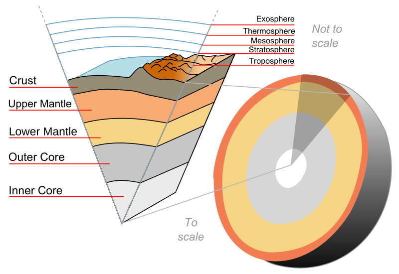
Cutaway of the Earth showing the layers to the core
Credit: Wikipedia During the investigation, the team focused on an area
between the Atlantic and the Indian Ocean, as the determined currents flows
were the highest here. Extremely fast changes (so-called magnetic jerks) were
observed in the year 2007 at the Earth’s surface. These are an indication for
sudden changes of liquid flows in the upper outer core and are important for
understanding the magneto-hydrodynamics in the Earth’s core. Using the
satellite data, a clear signal of gravity data from the Earth’s core could be
received for the first time.
Fig. S2. Spatial and temporal scales of the physical
processes causing mass variations in the Earth system. The searched-for core
signals, the magnetic jerks, are shown in yellow (adapted from ref. 15).
This results in consequences for the existing conceptual
models. Until now, for example, it was assumed that the differences in the
density of the molten iron in the earth’s core are not large enough to generate
a measurable signal in the earth’s gravitational field. The newly determined
mass flows in the upper outer core allow a new approach to Earth’s core
hydrodynamics.
Original article:
“Recent changes of the Earth’s core derived from satellite
observations of magnetic and gravity fields”, Mioara Mandea, Isabelle Panet, Vincent
Lesur, Olivier de Viron, Michel Diament, and Jean-Louis Le Mouël, PNAS 2012;
doi:10.1073/pnas.1207346109



.jpg)