June 24, 2014 - EARTH - This past May was a scorcher. According to a new report, it was the hottest May in recorded history.
The National Oceanic and Atmospheric Administration announced Monday that combined average May temperatures on land and sea surfaces were at 1.33 degrees Fahrenheit above the 20th-century average of 58.6 degrees.
"Four of the five warmest Mays on record have occurred in the past five years," the NOAA also wrote in its report. The previous hottest May on record was in 2010.
The warmest regions last month were reportedly eastern Kazakhstan, central and northwestern Australia and parts of Indonesia, according to The Washington Post.
Scientists believe the higher temperatures are likely a sign of an impending El Niño, a periodic warming of Pacific Ocean waters which brings heavy rainfall but could also be beneficial to parts of the globe experiencing droughts.
The Climate Prediction Center says there is a 70 percent chance of El Niño returning this summer, increasing to an 80 percent chance by fall. The last major El Niño occurred in 1997, resulting in billions of dollars of damage around the world.
Kevin Trenberth, a climate scientist at the National Center for Atmospheric Research who's been monitoring sea levels, told Science magazine a forthcoming El Niño later this year could likely rival the one in '97. “I don’t think we’ve seen anything like this before,” he said. - Huffington Post.
ἀλήθεια - the state of not being hidden; Jesus Christ is your only answer!
Showing posts with label Earth Changes. Show all posts
Friday, August 8, 2014
Monday, November 4, 2013
MONUMENTAL EARTH CHANGES: Mass Methane Release Accelerating - Levels In The Atmosphere Over The Arctic Ocean Increasing At Unprecedented Levels!
November 02, 2013 - ARCTIC - Methane levels in the atmosphere over the Arctic Ocean are very high, as illustrated by the image below, by Leonid Yurganov, showing IASI methane readings for October 10-20, 2013.
Previous posts have discussed these high levels of methane, pointing at links between high methane levels over Arctic Ocean and earthquakes and volcanic activity.
Malcolm Light points at another factor that is contributing to the high methane levels observed over the Arctic Ocean in October 2013.
Malcolm says: The massive methane release in the Arctic this October is partly because the Gulf Stream waters got massive heating in the Atlantic off the North American coast in July. It takes the Gulf Stream currents almost 4 months to reach the emission sites along the southern side and end of the Eurasian Basin. This combined with the earthquake activity along the Gakkel Ridge and deep pyroclastic eruptions is escalating the rate of methane release by destabilizing the submarine Arctic methane hydrates at increasing rates.
The NOAA image below shows temperature anomalies for July 2013. NOAA adds that in July 2013 many regions were much warmer than average, with part of the northeastern Atlantic off the coast of North America observing record warmth.
The image below shows how water traveling along the Gulf Stream ends up in the Arctic Ocean. Water in the Gulf Stream travels at 4 miles per hour, but slows down to less than 1 mile per hour in the North-Atlantic Current. This means that water warmed up off Florida in July will start reaching waters beyond Svalbard in October.
The image below, from Malcolm Light's September 2012 post Further Confirmation of a Probable Arctic Sea Ice Loss by Late 2015, shows how warm water flows into the Arctic Ocean and warms up methane hydrates and free gas held in sediments under the Arctic Ocean.
The image below shows the methane readings over the past few days on the Northern Hemisphere.
Below image shows the Northern Hemisphere on October 26 - 27, 2013, a period of just over one day. Methane readings of 1950 ppb and higher show up in yellow. Peak reading on October 27, 2013, was 2369 ppb.
The image below, created by Harold Hensel with methanetracker, shows methane over the Arctic Ocean in three ranges, with the highest readings (1950 ppb and higher) in red.
Harold adds: "Methane increased again in the Arctic Circle yesterday, 10/27/2013. So what were the headlines in the news? It wasn't this which is more important than anything the media has to report. This is surreal to me."
Previous posts have discussed these high levels of methane, pointing at links between high methane levels over Arctic Ocean and earthquakes and volcanic activity.
Malcolm Light points at another factor that is contributing to the high methane levels observed over the Arctic Ocean in October 2013.
Malcolm says: The massive methane release in the Arctic this October is partly because the Gulf Stream waters got massive heating in the Atlantic off the North American coast in July. It takes the Gulf Stream currents almost 4 months to reach the emission sites along the southern side and end of the Eurasian Basin. This combined with the earthquake activity along the Gakkel Ridge and deep pyroclastic eruptions is escalating the rate of methane release by destabilizing the submarine Arctic methane hydrates at increasing rates.
The NOAA image below shows temperature anomalies for July 2013. NOAA adds that in July 2013 many regions were much warmer than average, with part of the northeastern Atlantic off the coast of North America observing record warmth.
The image below shows how water traveling along the Gulf Stream ends up in the Arctic Ocean. Water in the Gulf Stream travels at 4 miles per hour, but slows down to less than 1 mile per hour in the North-Atlantic Current. This means that water warmed up off Florida in July will start reaching waters beyond Svalbard in October.
The image below, from Malcolm Light's September 2012 post Further Confirmation of a Probable Arctic Sea Ice Loss by Late 2015, shows how warm water flows into the Arctic Ocean and warms up methane hydrates and free gas held in sediments under the Arctic Ocean.
The image below shows the methane readings over the past few days on the Northern Hemisphere.
Below image shows the Northern Hemisphere on October 26 - 27, 2013, a period of just over one day. Methane readings of 1950 ppb and higher show up in yellow. Peak reading on October 27, 2013, was 2369 ppb.
The image below, created by Harold Hensel with methanetracker, shows methane over the Arctic Ocean in three ranges, with the highest readings (1950 ppb and higher) in red.
Harold adds: "Methane increased again in the Arctic Circle yesterday, 10/27/2013. So what were the headlines in the news? It wasn't this which is more important than anything the media has to report. This is surreal to me."
Thursday, September 19, 2013
MONUMENTAL EARTH CHANGES: The Break In Rains Help Colorado Flood Rescue Efforts - Death Toll Now At 7; About 400 Missing; Scores Of Homes, Bridges And Roads Washed Away!
September 16, 2013 - UNITED STATES - The death toll from the massive flooding along Colorado's Front Range grew to seven Monday as search-and-rescue operations intensified and the storms that have pummeled the state for a week began to subside.
State emergency officials did not release names or details about the latest victims. Three deaths were confirmed in Boulder County and two in El Paso County, and two are presumed dead in Larimer County.
Hundreds of residents remain unaccounted for, but the state's earlier estimate of more than 1,250 missing was expected to be significantly lowered after Larimer County officials reported about 400 missing, down from earlier state estimates of about 1,000. Exact numbers remain elusive, since many residents live in isolated or hard-to-reach mountain communities where scores of bridges and roads have been washed out and telephone, cellphone and Internet service has been disrupted for several days.
The National Weather Service expected warmer, drier conditions in the state Monday with rain ending at night. Yet officials warned there is still potential for flash flooding in and near saturated foothills late Monday afternoon into early evening, as lingering air moisture combined with warmer temperatures could cause scattered thunderstorms.
More than 1,200 people were rescued by vehicles and helicopters Saturday, but 16 rescue helicopters were grounded Sunday after some parts of flooded areas got up to 4 inches of new rain. After seven straight days of rain, some regions have gotten up to 20 inches of rainfall, as much as falls in a typical year.
Colorado National Guard Lt. James Goff says 19 helicopters are available for search-and-rescue. The air rescue operation is already one of the nation's largest since Hurricane Katrina, but has been hampered by steady rains and foggy conditions. As the weather breaks, officials urged those unable to communicate by phone to signal helicopters with sheets, mirrors, flares and signal fires.
The death toll from the massive flooding along Colorado's Front Range grew to seven Monday as search-and-rescue operations intensified and the storms that have pummeled the state for a week began to subside.
State emergency officials did not release names or details about the latest victims. Three deaths were confirmed in Boulder County and two in El Paso County, and two are presumed dead in Larimer County.
Hundreds of residents remain unaccounted for, but the state's earlier estimate of more than 1,250 missing was expected to be significantly lowered after Larimer County officials reported about 400 missing, down from earlier state estimates of about 1,000. Exact numbers remain elusive, since many residents live in isolated or hard-to-reach mountain communities where scores of bridges and roads have been washed out and telephone, cellphone and Internet service has been disrupted for several days.
The National Weather Service expected warmer, drier conditions in the state Monday with rain ending at night. Yet officials warned there is still potential for flash flooding in and near saturated foothills late Monday afternoon into early evening, as lingering air moisture combined with warmer temperatures could cause scattered thunderstorms.
WATCH: Flooding in Larimer County.
More than 1,200 people were rescued by vehicles and helicopters Saturday, but 16 rescue helicopters were grounded Sunday after some parts of flooded areas got up to 4 inches of new rain. After seven straight days of rain, some regions have gotten up to 20 inches of rainfall, as much as falls in a typical year.
Colorado National Guard Lt. James Goff says 19 helicopters are available for search-and-rescue. The air rescue operation is already one of the nation's largest since Hurricane Katrina, but has been hampered by steady rains and foggy conditions. As the weather breaks, officials urged those unable to communicate by phone to signal helicopters with sheets, mirrors, flares and signal fires. - USA Today.
![]() |
A house in the path of the recent floods is destroyed in Jamestown, Colo.(Photo: Helen H. Richardson, AP)
|
State emergency officials did not release names or details about the latest victims. Three deaths were confirmed in Boulder County and two in El Paso County, and two are presumed dead in Larimer County.
Hundreds of residents remain unaccounted for, but the state's earlier estimate of more than 1,250 missing was expected to be significantly lowered after Larimer County officials reported about 400 missing, down from earlier state estimates of about 1,000. Exact numbers remain elusive, since many residents live in isolated or hard-to-reach mountain communities where scores of bridges and roads have been washed out and telephone, cellphone and Internet service has been disrupted for several days.
The National Weather Service expected warmer, drier conditions in the state Monday with rain ending at night. Yet officials warned there is still potential for flash flooding in and near saturated foothills late Monday afternoon into early evening, as lingering air moisture combined with warmer temperatures could cause scattered thunderstorms.
![]() |
| Joey Schendel searches for submerged items while helping neighbors clean their property in a flooded area on Sept. 16 in Hygeine, Colo. Brennan Linsley, AP |
![]() |
| Flood victims are helped off of a military helicopter. Ed Andrieski, AP |
More than 1,200 people were rescued by vehicles and helicopters Saturday, but 16 rescue helicopters were grounded Sunday after some parts of flooded areas got up to 4 inches of new rain. After seven straight days of rain, some regions have gotten up to 20 inches of rainfall, as much as falls in a typical year.
Colorado National Guard Lt. James Goff says 19 helicopters are available for search-and-rescue. The air rescue operation is already one of the nation's largest since Hurricane Katrina, but has been hampered by steady rains and foggy conditions. As the weather breaks, officials urged those unable to communicate by phone to signal helicopters with sheets, mirrors, flares and signal fires.
The death toll from the massive flooding along Colorado's Front Range grew to seven Monday as search-and-rescue operations intensified and the storms that have pummeled the state for a week began to subside.
State emergency officials did not release names or details about the latest victims. Three deaths were confirmed in Boulder County and two in El Paso County, and two are presumed dead in Larimer County.
![]() |
| Mike Steinpach shovels mud from the basement of Stan McDonald's house after heavy flooding on Sept. 15 in Longmont, Colo. Hyoung Chang, The Denver Post, via AP |
![]() |
| A truck rests next to a washed out railroad track in the Champion Greens neighborhood in Longmont. Craig F. Walker, The Denver Post, via AP |
Hundreds of residents remain unaccounted for, but the state's earlier estimate of more than 1,250 missing was expected to be significantly lowered after Larimer County officials reported about 400 missing, down from earlier state estimates of about 1,000. Exact numbers remain elusive, since many residents live in isolated or hard-to-reach mountain communities where scores of bridges and roads have been washed out and telephone, cellphone and Internet service has been disrupted for several days.
The National Weather Service expected warmer, drier conditions in the state Monday with rain ending at night. Yet officials warned there is still potential for flash flooding in and near saturated foothills late Monday afternoon into early evening, as lingering air moisture combined with warmer temperatures could cause scattered thunderstorms.
WATCH: Flooding in Larimer County.
More than 1,200 people were rescued by vehicles and helicopters Saturday, but 16 rescue helicopters were grounded Sunday after some parts of flooded areas got up to 4 inches of new rain. After seven straight days of rain, some regions have gotten up to 20 inches of rainfall, as much as falls in a typical year.
Colorado National Guard Lt. James Goff says 19 helicopters are available for search-and-rescue. The air rescue operation is already one of the nation's largest since Hurricane Katrina, but has been hampered by steady rains and foggy conditions. As the weather breaks, officials urged those unable to communicate by phone to signal helicopters with sheets, mirrors, flares and signal fires. - USA Today.
Sunday, August 11, 2013
EXTREME WEATHER: Complex Of Severe Earth Changes In The United States And Europe - Severe Storm, Flooding Risk From Omaha To St. Louis And Oppressive Heat Bakes Much Of Europe!
August 02, 2013 - UNITED STATES & EUROPE - Here are two reports from AccuWeather, illustrating the extreme weather taking place on either side of the Atlantic Ocean.
A series of thunderstorms will continue to roll along over the central Plains, and some areas will be hit with severe weather into Saturday.
As one complex of storms that brought severe weather to Nebraska Thursday evening weakens over Missouri, a new batch of storms was already bringing severe weather to parts of South Dakota on Friday morning.
This new complex of storms will roll southeastward into Saturday across Nebraska, Missouri and parts of Kansas and Iowa. The storms could reach as far as Tennessee, northern Mississippi and Alabama later Saturday.
Cities and suburbs from Omaha, Neb., to Kansas City and St. Louis, Mo., are most likely have disruptive and damaging storms.
While frequent lightning strikes and hail will hit some communities hard, the greatest threat from the storms is damaging wind gusts and flash flooding.
Motorists should expect delays along I-29, I-70 and I-80 in the region, due to localized blinding downpours and excess water on the road surface.
For a few locations, this will be the second round in as many days of strong to severe thunderstorms, including parts of South Dakota, Nebraska and Kansas.
Much of the new rain falling on top of saturated ground will just run off into streams and rivers. People in unprotected, low-lying areas that are prone to flooding should keep a watchful eye.
Never drive across flooded roadways, as only about a foot of water can cause your vehicle to loose traction and could be swept downstream.
The rain is not unwanted in some areas. Portions of Iowa, for example, have had less than 25 percent of their normal rainfall during July.
Areas from western Nebraska southward to West Texas over the High Plains are in great need of rain. Much of this area is in extreme to exceptional drought. The storms into Saturday will avoid much of the drought areas over the High Plains.
Another complex of storms may fire farther south Saturday night and Sunday, beginning over parts of Kansas.
The storms are firing along shifting boundary between unusually cool air over the Midwest and 100-degree heat over much of Texas.
Interestingly, one of the disturbances producing the rounds of thunderstorms over the Plains has a chance at surviving a trip to the Gulf of Mexico early next week. Once in a while, such disturbances can develop into a tropical system.
August got off to a scorching start across much of central and western Europe. A blast of hot air spread across the region allowing temperatures to soar into the mid- and upper 30s Celsius.
The hot spell preceded a storm system moving into the northern United Kingdom. Ahead of this storm, a flow of hot air from the south made for a very uncomfortable Thursday and Friday in many places.
A smattering of oppressively hot temperature observations include 35C (95F) in Rome, 34 in London, 33 in Frankfurt and 38 (101F) in Madrid.
While cooler weather pressed into England Friday, the heat was still on in central Europe. Florence, Italy climbed to 37C (99F) late in the afternoon while Frankfurt topped out near 35C.
This excessive heat continued the trend of a warm last month in much of Europe. Since July 1, locations such as London, Paris and Madrid have all averaged at least 2.8 degrees Celsius (5F) above normal.
Thankfully, a break from the heat is on the way for western Europe this weekend and into next week. Cooler air will filter into the region from the northern Atlantic and bring temperatures much closer to average.
While the western part of the continent cools, the core of the heat will shift eastward to include Hungary, Slovakia, Slovenia and Croatia. Southern Spain as well as Italy will also remain quite warm.
Severe Storm, Flooding Risk From Omaha To St. Louis.
A series of thunderstorms will continue to roll along over the central Plains, and some areas will be hit with severe weather into Saturday.
As one complex of storms that brought severe weather to Nebraska Thursday evening weakens over Missouri, a new batch of storms was already bringing severe weather to parts of South Dakota on Friday morning.
This new complex of storms will roll southeastward into Saturday across Nebraska, Missouri and parts of Kansas and Iowa. The storms could reach as far as Tennessee, northern Mississippi and Alabama later Saturday.
Cities and suburbs from Omaha, Neb., to Kansas City and St. Louis, Mo., are most likely have disruptive and damaging storms.
While frequent lightning strikes and hail will hit some communities hard, the greatest threat from the storms is damaging wind gusts and flash flooding.
Motorists should expect delays along I-29, I-70 and I-80 in the region, due to localized blinding downpours and excess water on the road surface.
For a few locations, this will be the second round in as many days of strong to severe thunderstorms, including parts of South Dakota, Nebraska and Kansas.
Much of the new rain falling on top of saturated ground will just run off into streams and rivers. People in unprotected, low-lying areas that are prone to flooding should keep a watchful eye.
Never drive across flooded roadways, as only about a foot of water can cause your vehicle to loose traction and could be swept downstream.
The rain is not unwanted in some areas. Portions of Iowa, for example, have had less than 25 percent of their normal rainfall during July.
Areas from western Nebraska southward to West Texas over the High Plains are in great need of rain. Much of this area is in extreme to exceptional drought. The storms into Saturday will avoid much of the drought areas over the High Plains.
Another complex of storms may fire farther south Saturday night and Sunday, beginning over parts of Kansas.
The storms are firing along shifting boundary between unusually cool air over the Midwest and 100-degree heat over much of Texas.
Interestingly, one of the disturbances producing the rounds of thunderstorms over the Plains has a chance at surviving a trip to the Gulf of Mexico early next week. Once in a while, such disturbances can develop into a tropical system.
Oppressive Heat Bakes Much Of Europe.
August got off to a scorching start across much of central and western Europe. A blast of hot air spread across the region allowing temperatures to soar into the mid- and upper 30s Celsius.
The hot spell preceded a storm system moving into the northern United Kingdom. Ahead of this storm, a flow of hot air from the south made for a very uncomfortable Thursday and Friday in many places.
A smattering of oppressively hot temperature observations include 35C (95F) in Rome, 34 in London, 33 in Frankfurt and 38 (101F) in Madrid.
While cooler weather pressed into England Friday, the heat was still on in central Europe. Florence, Italy climbed to 37C (99F) late in the afternoon while Frankfurt topped out near 35C.
This excessive heat continued the trend of a warm last month in much of Europe. Since July 1, locations such as London, Paris and Madrid have all averaged at least 2.8 degrees Celsius (5F) above normal.
Thankfully, a break from the heat is on the way for western Europe this weekend and into next week. Cooler air will filter into the region from the northern Atlantic and bring temperatures much closer to average.
While the western part of the continent cools, the core of the heat will shift eastward to include Hungary, Slovakia, Slovenia and Croatia. Southern Spain as well as Italy will also remain quite warm.
Labels:
2012,
2013,
Damaging Winds,
drought,
Earth Changes,
England,
Europe,
extreme weather,
Flash Floodking,
France,
heat wave,
Humidity,
Nebraska,
Omaha,
Spain,
St. Louis,
Thunderstorms,
Weather Anomalies
Saturday, August 10, 2013
Two studies use phrase “10 times faster” to describe climate changes
Climate warming happening 10 times faster than in the past 65 million years. Antarctic permafrost melting 10 times faster than in 11,000 years,
Via earthsky.org, 2 August 2013 (Thanks Connie) - Two recent studies suggest that the climate warming occurring on Earth today is happening at a dramatically fast rate. It’s this rate of change, scientists say – the speed with which average global temperatures are expected to climb over the coming decades – that will make the ongoing climate warming troublesome for living things on Earth. Both groups of scientists used the phrase “10 times faster” to describe climate changes.
One study, from Stanford University, suggests that climate change is happening 10 times faster than it has at any time in the past 65 million years. The other study, from the University of Texas, suggests that Antarctic permafrost is now melting 10 times faster than in 11,000 years, adding further evidence that Earth’s Antarctic is, in fact, warming just as Earth’s Arctic is. Click the links below to learn more about these studies.
The top map shows global temperatures in the late 21st century, based on current warming trends. The bottom map illustrates the velocity of climate change, or how far species in any given area will need to migrate by the end of the 21st century to experience climate similar to present.
Noah Diffenbaugh and Chris Field, both senior fellows at the Stanford Woods Institute for the Environment, published these results as part of a special report on climate change in the August 2013 issue of Science. They conducted a “targeted but broad” review of scientific literature on aspects of climate change that can affect ecosystems, and they investigated how recent observations and projections for climate change in the coming century compare to past events in Earth’s history.
For instance, they compare the current warming to the 5-degree-Celsius temperature hike that occurred 20,000 years ago, as Earth emerged from the last ice age. They say that change was:
… comparable to the high-end of the projections for warming over the 20th and 21st centuries.
The difference is that, at the end of the last ice age, the warming took place over thousands of years. The same warming now is expected to occur over decades. Diffenbaugh and Field note that, as the climate warmed at the end of the last ice age, plants and animals moved northward to cooler climates. Similar (but possibly less successful?) migrations are expected in the coming years.
Diffenbaugh and Field also say in their press release that:
… some of the strongest evidence for how the global climate system responds to high levels of carbon dioxide comes from paleoclimate studies. Fifty-five million years ago, carbon dioxide in the atmosphere was elevated to a level comparable to today. The Arctic Ocean did not have ice in the summer, and nearby land was warm enough to support alligators and palm trees.
But they say there are two key differences for ecosystems in the coming decades compared with the geologic past. The rapid pace of modern climate change is one. The other is that:
… today there are multiple human stressors that were not present 55 million years ago, such as urbanization and air and water pollution.
Read more about Diffenbaugh and Field’s study from Stanford
One of the McMurdo Dry Valleys in Antarctica. Scientists found a rapid retreat of ground ice in Garwood Valley, one of the Dry Valleys, similar to the rates of permafrost melt observed in the coastal Arctic. Photo by Bryan Kiechie on Flickr, via Motherboard
Landsat satellite mosaic of Antarctica, showing the location of the Dry Valleys, via University of Texas
Prior to this finding, the permafrost in this region of Antarctica was assumed to be stable. These researchers say this permafrost melting in this part of Antarctica has accelerated so that it’s now “comparable to the Arctic.”
UT’s Joseph Levy and his team documented the change through LIDAR – a detection system that works on the principle of radar, but uses light from a laser – and time-lapse photography. They found a rapid retreat of ground ice in Garwood Valley, one of the McMurdo Dry Valleys, similar to the lower rates of permafrost melt observed in the coastal Arctic and Tibet. Levy said:
The big tell here is that the ice is vanishing — it’s melting faster each time we measure. This is a dramatic shift from recent history.
Describing this study for Motherboard, Mat McDermott wrote:
As opposed to the potentially catastrophic bump in greenhouse gas emissions that could result if Arctic permafrost quickly melts, scientists here are presenting their findings as more of an interesting geologic curiosity. As the ground continues to thaw, researcher believe the landscape will sink and buckle, creating retrogressive thaw slumps.
Furthermore, unlike other ice melting in Antarctica which can contribute significantly to sea-level rise depending upon whether its already floating on the water or resting on solid ground, the ground ice melting here isn’t really a major component of the frozen water on the continent.
Read more about Levy’s study from the University of Texas
Bottom line: Two recent studies use the phrase “10 times faster” to describe ongoing climate warming. One study, from Stanford University, suggests that climate change is happening 10 times faster than it has at any time in the past 65 million years. The other study, from the University of Texas, suggests that Antarctic permafrost is now melting 10 times Faster than it has in 11,000 years, adding further evidence that Earth’s Antarctic is, in fact, warming just as Earth’s Arctic is.
Wednesday, July 31, 2013
Earth change roundup for the end of July 2013
Here are a few articles I put together, which are earth change related events from the past few daysto a week.
Tragedy: Seven people drowned at a number of resorts across the Mediterranean coast of France yesterday, including at Carnon
28 July 2013 - 'Seven people drown in seas off France's Mediterranean coast after 80mph winds and unpredictable currents cause treacherous conditions' - "Another three in 'serious condition' after escaping from the sea. Four victims died on the beaches, while three others died in hospital"
July 25 - 'Report confirms drought worst in nearly 70 years' - (New Zealand) "A comparative study on the 2013 drought released today by the Ministry for Primary Industries (MPI) confirms it was one of the most extreme on record for New Zealand and the worst since 1945-46. The 2013 drought was also one of the most widespread New Zealand has experienced with only the drought of 1972-73 that affected Wairarapa, Tasman, Otago and Southland coming close to its geographical spread."
26 July - 'Siberia Heat: Did The Arctic Region Break A Heat Record?' - "Did the Arctic region break a heat record? According to English-language outlet The Siberian Times, temperatures of 32 degrees Celsius, or 89.6 degrees Fahrenheit, were recorded in the Siberian city of Norilsk on July 21. The average temperature in July in the region is 13.6 C, or 56.48 F."

29 July - 'Earthquakes Contribute to Global Warming by Releasing Methane from Ocean Floor' - "A study conducted by Swiss and German scientists has uncovered a natural source of greenhouse gas emission - methane. Researchers emphasize that climate scientists need to consider the amount of methane being released as earthquakes rip open ocean floors, in order to better understand the various sources of greenhouse gases."
26 July 2013 - 'VOLCANO WATCH: U.S. ranks high with active volcanoes' - "HAWAII VOLCANOES NATIONAL PARK, Hawaii – When Mount St. Helens erupted explosively in 1980, most people were unaware that the U.S. ranks as one of the top countries in the world in the number of geologically young, active volcanoes. An updated review of the Nation’s active volcanism from 1980 through the end of 2012, however, shows that 107 eruptions occurred at 32 volcanoes (most of which are located in Alaska), and at least 41 episodes of unrest were observed at 13 volcanoes."
29 July 2013 - 'NFU claims extreme weather poses biggest threat to British farming' - "Erratic swings from floods to heatwaves and drought caused by climate change is devastating harvests, says NFU president"
29 July 2013 - 'Rainfall fell by 58% comparing to last year, water reductions in Tehran, Iran' - "Heatwave is scourging Iran bringing temperatures to alarming heights which, combined with the lack of rainfall, created drinking water shortages and reductions."
29 July 2013 - 'Heatwave and hailstones the size of tennis balls, Germany' - "While most of Germany endures exceptional heatwave, eyewitnesses from village of Wassel in Sehnte reported hailstones the size of tennis balls on Saturday, July 27, 2013. AP brings video with images of damaged houses and vehicles:"
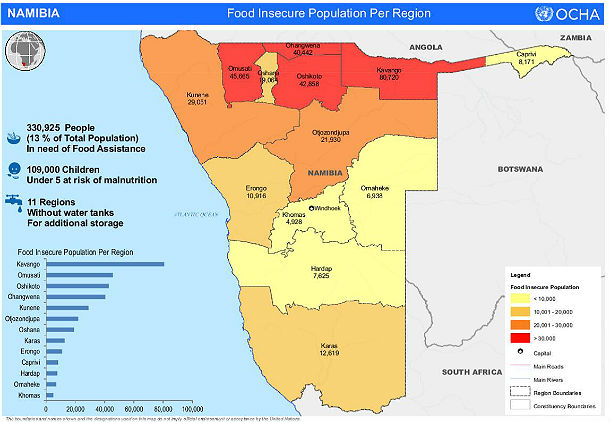
27 July 2013 - 'Hundreds of thousands affected by drought in Namibia' - "Namibian government declared a state of emergency on May 17, 2013 due to prolonged dry season which resulted in widespread crop failure across the country. About 780,000 people (approximately one third of Namibia’s entire population) are now classified as food insecure. "
27 July 2013 - '21 dead as floods strike quake-hit Chinese province' - "At least 21 people have been killed and four reported missing in floods and mudslides that hit a Chinese province where at least 95 others died this week in twin earthquakes, state media reported on Saturday."
28 July 2013 - 'Rain moves through Orange County as flooding cleanup continues' - "CHAPEL HILL, N.C. - A heavy rain system that left flooding in part of North Carolina moved through Orange County Saturday where people are still cleaning up from flooding last month."
27 July 2013 - 'PAGASA: Flash floods threaten Bicol, Vis-Min as potential cyclone moves closer to Davao City' - "Residents of Bicol, Visayas and Mindanao were advised to brace for possible flash floods and landslides from a potential cyclone - a low-pressure area - that moved closer to Davao City before noon on Saturday."
29 July 2013 - 'Heatwaves will make crops produce smaller grains' - "Extreme weather is ruining farmlands as British farmers find it difficult to cope with volatile seasonal changes"
27 July 2013 - 'Environmental disaster in Canada - Primrose oilsands site in Alberta unable to stop oil leaking for over nine weeks' - "Canadian Natural Resources Ltd. (CNR) operates the Primrose oilsands facility northeast of Edmonton where four ongoing underground oil blowouts have contaminated forest, muskeg and a lake and have already killed dozens animals. The sites are located in a remote area which has restricted access to the public. Alberta's Oil Sands is the third-largest crude oil reserve in the world, next to Saudi Arabia and Venezuela. Alberta government and the company hasn't yet officially confirmed the cause of the blowout, the amount of spilled material, wildlife impacts, water-quality monitoring or a plan to stop the spill."
29 July 2013 - 'Environmental Disaster: Oil Spill Reaches Thai Holiday Island Ko Samet' - "An estimated 50,000 gallons of oil spilled into the sea in the Gulf of Thailand through a leak in an oil pipeline this weekend. The Thai Navy tried unsuccessfully on Sunday to prevent the oil slick to reach the coast. Some floating barriers were deposited off the coast to catch the oil film and finally aspirate it."
29 July 2013 - 'Latest threat to Great Lakes: Scientists discover floating masses of tiny plastic bits' - "TRAVERSE CITY, Michigan — Already ravaged by toxic algae, invasive mussels and industrial pollution, the Great Lakes now confront another potential threat that few had even imagined until recently: untold millions of plastic litter bits, some visible only through a microscope."
28 July 2013 - 'Seven people drown in seas off France's Mediterranean coast after 80mph winds and unpredictable currents cause treacherous conditions' - "Another three in 'serious condition' after escaping from the sea. Four victims died on the beaches, while three others died in hospital"
July 25 - 'Report confirms drought worst in nearly 70 years' - (New Zealand) "A comparative study on the 2013 drought released today by the Ministry for Primary Industries (MPI) confirms it was one of the most extreme on record for New Zealand and the worst since 1945-46. The 2013 drought was also one of the most widespread New Zealand has experienced with only the drought of 1972-73 that affected Wairarapa, Tasman, Otago and Southland coming close to its geographical spread."
26 July - 'Siberia Heat: Did The Arctic Region Break A Heat Record?' - "Did the Arctic region break a heat record? According to English-language outlet The Siberian Times, temperatures of 32 degrees Celsius, or 89.6 degrees Fahrenheit, were recorded in the Siberian city of Norilsk on July 21. The average temperature in July in the region is 13.6 C, or 56.48 F."
29 July - 'Earthquakes Contribute to Global Warming by Releasing Methane from Ocean Floor' - "A study conducted by Swiss and German scientists has uncovered a natural source of greenhouse gas emission - methane. Researchers emphasize that climate scientists need to consider the amount of methane being released as earthquakes rip open ocean floors, in order to better understand the various sources of greenhouse gases."
26 July 2013 - 'VOLCANO WATCH: U.S. ranks high with active volcanoes' - "HAWAII VOLCANOES NATIONAL PARK, Hawaii – When Mount St. Helens erupted explosively in 1980, most people were unaware that the U.S. ranks as one of the top countries in the world in the number of geologically young, active volcanoes. An updated review of the Nation’s active volcanism from 1980 through the end of 2012, however, shows that 107 eruptions occurred at 32 volcanoes (most of which are located in Alaska), and at least 41 episodes of unrest were observed at 13 volcanoes."
29 July 2013 - 'NFU claims extreme weather poses biggest threat to British farming' - "Erratic swings from floods to heatwaves and drought caused by climate change is devastating harvests, says NFU president"
29 July 2013 - 'Rainfall fell by 58% comparing to last year, water reductions in Tehran, Iran' - "Heatwave is scourging Iran bringing temperatures to alarming heights which, combined with the lack of rainfall, created drinking water shortages and reductions."
29 July 2013 - 'Heatwave and hailstones the size of tennis balls, Germany' - "While most of Germany endures exceptional heatwave, eyewitnesses from village of Wassel in Sehnte reported hailstones the size of tennis balls on Saturday, July 27, 2013. AP brings video with images of damaged houses and vehicles:"
28 July 2013 - 'Record rainfall for Philadelphia, flooding for entire region' - "A Sunday afternoon deluge turned roads into rivers in South Jersey, submerging cars and stranding drivers, and set a record for one-day rainfall in Philadelphia."
27 July 2013 - '21 dead as floods strike quake-hit Chinese province' - "At least 21 people have been killed and four reported missing in floods and mudslides that hit a Chinese province where at least 95 others died this week in twin earthquakes, state media reported on Saturday."
28 July 2013 - 'Rain moves through Orange County as flooding cleanup continues' - "CHAPEL HILL, N.C. - A heavy rain system that left flooding in part of North Carolina moved through Orange County Saturday where people are still cleaning up from flooding last month."
27 July 2013 - 'PAGASA: Flash floods threaten Bicol, Vis-Min as potential cyclone moves closer to Davao City' - "Residents of Bicol, Visayas and Mindanao were advised to brace for possible flash floods and landslides from a potential cyclone - a low-pressure area - that moved closer to Davao City before noon on Saturday."
29 July 2013 - 'Heatwaves will make crops produce smaller grains' - "Extreme weather is ruining farmlands as British farmers find it difficult to cope with volatile seasonal changes"
27 July 2013 - 'Environmental disaster in Canada - Primrose oilsands site in Alberta unable to stop oil leaking for over nine weeks' - "Canadian Natural Resources Ltd. (CNR) operates the Primrose oilsands facility northeast of Edmonton where four ongoing underground oil blowouts have contaminated forest, muskeg and a lake and have already killed dozens animals. The sites are located in a remote area which has restricted access to the public. Alberta's Oil Sands is the third-largest crude oil reserve in the world, next to Saudi Arabia and Venezuela. Alberta government and the company hasn't yet officially confirmed the cause of the blowout, the amount of spilled material, wildlife impacts, water-quality monitoring or a plan to stop the spill."
29 July 2013 - 'Environmental Disaster: Oil Spill Reaches Thai Holiday Island Ko Samet' - "An estimated 50,000 gallons of oil spilled into the sea in the Gulf of Thailand through a leak in an oil pipeline this weekend. The Thai Navy tried unsuccessfully on Sunday to prevent the oil slick to reach the coast. Some floating barriers were deposited off the coast to catch the oil film and finally aspirate it."
29 July 2013 - 'Latest threat to Great Lakes: Scientists discover floating masses of tiny plastic bits' - "TRAVERSE CITY, Michigan — Already ravaged by toxic algae, invasive mussels and industrial pollution, the Great Lakes now confront another potential threat that few had even imagined until recently: untold millions of plastic litter bits, some visible only through a microscope."
Sunday, May 26, 2013
Earth change event predicted in the Atlantic Ocean, 22 May 2013, by Doctor Simon Atkins - More Global Coastal Event validation
I have stumbled upon another source which validates something similar to the Global Coastal Event as predicted by Clif High via the webbot and which is seen from a number of other sources such as the Farsight Institute climate change remote viewing study, conducted by Courtney Brown.
The prediction is based around an ocean type of event, possibly related to an earthquake and/or volcanic eruption, in the Atlantic with the possibility of similar smaller scale 'ocean' events in the Pacific, Indian and South Atlantics oceans. The date predicted for this event is around the 22nd of May, this month.
Doctor Simon Atkins from Advanced Forecasting Corporation is the person behind this prediction. Simon Atkins has a team of people within his organisation.
This organisation is basically a data forecasting and planetary risk management company. They predict weather, climate change, earth shifts in relation to such events as volcanoes, earthquakes, sink holes, solar flares, cosmic rays, etc.
Simon Atkins started off studying back in the 90's with a Bachelor of Atmospheric Science and went on to complete two Doctorate degrees, one in India and one in the USA. One of these is based on energetics and natural medicine and the other on planetary electro magnetics.
Their company generates their information through a number of scientific methods. One example would be genetic algorithms, which essentially learn from their mistakes from the information being entered by humans. Another would be through neural network black box's, with information being entered based around such data as electromagnetic information from the sun, solar flares, the temperatures of the stratosphere and other parameters that all go to help explain the mechanics and the future of the weather.
With regards to this global coastal event type prediction, Doctor Simon Atkins has mentioned that the systems used to predict this is a combination of technology and science, but also clairvoyance and remote sensing. Doctor Simon Atkins has said that electromagnetic ionic interface will pull a 'light wave' into the north Atlantic. He explains that there are secondary, tertiary and quaternary effects / impacts and the focus wont just be in the North Atlantic.
He says that "lighter" force fields are in other areas, such as the the Pacific, Indian and South Atlantic Oceans. In his analysis, he said he concentrated on the main force because it is hundreds of times larger in the North Atlantic compared to elsewhere. Simon Atkins says that where they see the most social / economic shift is on the U.S. East Coast, then secondly in Europe. Further analysis shows that it appears the light wave will be hitting opposite to the Earth's spin, which would mean that the forced ocean event would push toward the USA and Central America.
Doctor Simon Atkins was interviewed on the G2 files on November 19, 2012 by Neil Bigelow. He discusses this prediction I have mentioned above. The interview can be downloaded by the link below (right click, save as),
http://freeman.theanomalieschannel.com/G2-Files-Advance-Forecasting.mp3
Simon has explained that his company does not get any funding from Government and he has no concern over loosing his job, as its his company, and therefore he is very blunt about the way he provides certain information.
He speaks of the NASA video a few years back, from the Director, warning the employees of NASA and the families to be prepared for a coming celestial event. Simon Atkins then speaks of the solar maximum coming in 2013 and through plotting and going over old data, he is able to predict when its going to be the most active and he is expecting some very high activity at certain points in time.
Simon Atkins mentions that these events, where the suns activity is very high, such as many large solar flares like we have seen over the past two days, effects our consciousness and 'herd mentality'. Basically what I think he means is that people may act strange or different during this time, but it may also affect our spirituality in a sense, from a consciousness viewpoint.
Simon Atkins says that the sun affects social chaos, the markets, group mentality and more.
Simon Atkins says through the laws of attraction, in relation to electromagnetics we should never think in fear as we create what we think. We are what we think he says. He says that its important they we think in 'love' energy, thinking positivity as this does make a difference.
Simon Atkins says that between the end of March 2013 and beginning of April 2013, there will be a strong cosmic/solar earth planetary event, which starts beyond the Sun. Simon references the book, 'The Universe in a Nutshell' where Stephen Hawking explains 14 different dimensions. Simon says we need to think of the source of this energy to be based around how dimensions work.
(Note that the date has been revised since that interview to the 22nd of May 2013)
He says we will see a huge surge in energy coming in a form, that is not necessarily visible but should be felt.
What is the impact? Through science and introductory remote viewing, what is seen is a a wall of water coming across the Atlantic Ocean at this time. Between Iceland, St Louis and the Canary Islands they are seeing a very high electromagnetic triangulated event
What they saw is a wall of water about 40 feet high moving 200 kmh towards the east coast of the United states, around the 22nd of May, 2013.
Neil Bigelow mentions the Farsight Institute remote viewing study which shows something similar by June 1st. Simon doesn't respond to that specifically, but then mentions that if enough people believe in correcting, or altering or cancelling this event, we can actually change the course of the future. He doesn't believe that its a definite event.
Simon Atkins says that the US Government knows this is coming. He speaks of how military bases have been moved further inland in the US.
Discussion goes into prepping about 23 minutes into this 1 hour interview, which I won't cover, as most of you are already aware of this sort of thing by now, if you have been following my blog. (The interview is 2 hours, but Simon Atkins is only on it for about an hour)
So there we go. It is very interesting that the focus is being put on the Atlantic Occean, where the Farsight remote viewing study and the webbot shows it being more of a Global event. However, as I said before I started covering this interview, Simon Atkins does mention that its possible something occurs in other parts of the world. I picked up this information from another site where he answered someone's email around the event.
Advanced Forecasting Corporation - http://afcw.com/
The prediction is based around an ocean type of event, possibly related to an earthquake and/or volcanic eruption, in the Atlantic with the possibility of similar smaller scale 'ocean' events in the Pacific, Indian and South Atlantics oceans. The date predicted for this event is around the 22nd of May, this month.
Doctor Simon Atkins from Advanced Forecasting Corporation is the person behind this prediction. Simon Atkins has a team of people within his organisation.
This organisation is basically a data forecasting and planetary risk management company. They predict weather, climate change, earth shifts in relation to such events as volcanoes, earthquakes, sink holes, solar flares, cosmic rays, etc.
Simon Atkins started off studying back in the 90's with a Bachelor of Atmospheric Science and went on to complete two Doctorate degrees, one in India and one in the USA. One of these is based on energetics and natural medicine and the other on planetary electro magnetics.
Their company generates their information through a number of scientific methods. One example would be genetic algorithms, which essentially learn from their mistakes from the information being entered by humans. Another would be through neural network black box's, with information being entered based around such data as electromagnetic information from the sun, solar flares, the temperatures of the stratosphere and other parameters that all go to help explain the mechanics and the future of the weather.
With regards to this global coastal event type prediction, Doctor Simon Atkins has mentioned that the systems used to predict this is a combination of technology and science, but also clairvoyance and remote sensing. Doctor Simon Atkins has said that electromagnetic ionic interface will pull a 'light wave' into the north Atlantic. He explains that there are secondary, tertiary and quaternary effects / impacts and the focus wont just be in the North Atlantic.
He says that "lighter" force fields are in other areas, such as the the Pacific, Indian and South Atlantic Oceans. In his analysis, he said he concentrated on the main force because it is hundreds of times larger in the North Atlantic compared to elsewhere. Simon Atkins says that where they see the most social / economic shift is on the U.S. East Coast, then secondly in Europe. Further analysis shows that it appears the light wave will be hitting opposite to the Earth's spin, which would mean that the forced ocean event would push toward the USA and Central America.
Doctor Simon Atkins was interviewed on the G2 files on November 19, 2012 by Neil Bigelow. He discusses this prediction I have mentioned above. The interview can be downloaded by the link below (right click, save as),
http://freeman.theanomalieschannel.com/G2-Files-Advance-Forecasting.mp3
I am going to summarise the above interview below for additional details on this forecast.
Simon has explained that his company does not get any funding from Government and he has no concern over loosing his job, as its his company, and therefore he is very blunt about the way he provides certain information.
He speaks of the NASA video a few years back, from the Director, warning the employees of NASA and the families to be prepared for a coming celestial event. Simon Atkins then speaks of the solar maximum coming in 2013 and through plotting and going over old data, he is able to predict when its going to be the most active and he is expecting some very high activity at certain points in time.
Simon Atkins mentions that these events, where the suns activity is very high, such as many large solar flares like we have seen over the past two days, effects our consciousness and 'herd mentality'. Basically what I think he means is that people may act strange or different during this time, but it may also affect our spirituality in a sense, from a consciousness viewpoint.
Simon Atkins says that the sun affects social chaos, the markets, group mentality and more.
Simon Atkins says through the laws of attraction, in relation to electromagnetics we should never think in fear as we create what we think. We are what we think he says. He says that its important they we think in 'love' energy, thinking positivity as this does make a difference.
Simon Atkins says that between the end of March 2013 and beginning of April 2013, there will be a strong cosmic/solar earth planetary event, which starts beyond the Sun. Simon references the book, 'The Universe in a Nutshell' where Stephen Hawking explains 14 different dimensions. Simon says we need to think of the source of this energy to be based around how dimensions work.
(Note that the date has been revised since that interview to the 22nd of May 2013)
He says we will see a huge surge in energy coming in a form, that is not necessarily visible but should be felt.
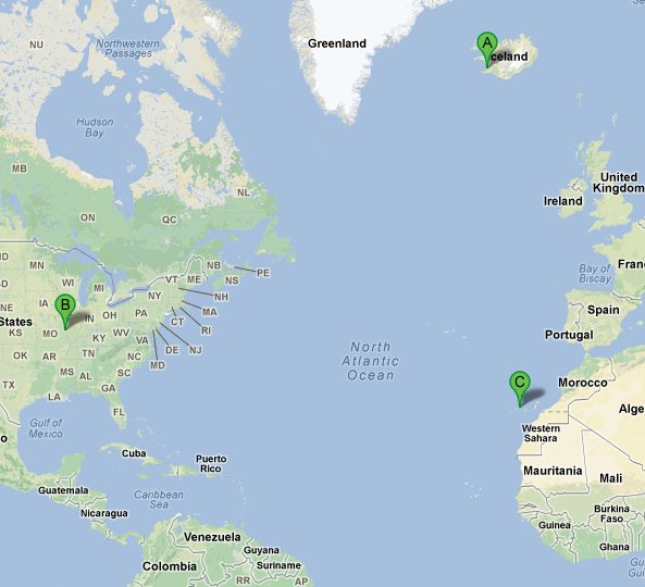
What is the impact? Through science and introductory remote viewing, what is seen is a a wall of water coming across the Atlantic Ocean at this time. Between Iceland, St Louis and the Canary Islands they are seeing a very high electromagnetic triangulated event
(I quickly made this up)
What they saw is a wall of water about 40 feet high moving 200 kmh towards the east coast of the United states, around the 22nd of May, 2013.
Neil Bigelow mentions the Farsight Institute remote viewing study which shows something similar by June 1st. Simon doesn't respond to that specifically, but then mentions that if enough people believe in correcting, or altering or cancelling this event, we can actually change the course of the future. He doesn't believe that its a definite event.
Simon Atkins says that the US Government knows this is coming. He speaks of how military bases have been moved further inland in the US.
Discussion goes into prepping about 23 minutes into this 1 hour interview, which I won't cover, as most of you are already aware of this sort of thing by now, if you have been following my blog. (The interview is 2 hours, but Simon Atkins is only on it for about an hour)
So there we go. It is very interesting that the focus is being put on the Atlantic Occean, where the Farsight remote viewing study and the webbot shows it being more of a Global event. However, as I said before I started covering this interview, Simon Atkins does mention that its possible something occurs in other parts of the world. I picked up this information from another site where he answered someone's email around the event.
Advanced Forecasting Corporation - http://afcw.com/
Subscribe to:
Posts (Atom)